The introductions of the country, dependency and region entries are in the native languages and in English. The other introductions are in English.
| |
|
Atlas-country

|
Ukraine
|
|
|
|
|
|
|
|
Україна
|
|
|
|
| Українська
|
Україна[1]
Україна – країна в Центрально-Схiдній Європі, розташована в південно-східній частині Східноєвропейської рівнини. Має спільні державні кордони з Росією на сході та північному сході, з Білоруссю на півночі, омивається Чорним та Азовським морями на півдні. На заході межує з Польщею та Словаччиною, на південному заході – з Угорщиною, Румунією та Молдовою. З Румунією та Росією Україна має не тільки сухопутний, а й морський кордон. Також через море Україна межує із Республікою Болгарія, Туреччиною та Грузією. Площа виключної (морської) економічної зони України становить понад 82 тис. км². Найбільшими портами Чорного моря є Одеса, Іллічівськ, Херсон, Севастополь, Азовського —Маріуполь, Бердянськ, Керч. Загальна протяжність кордонів 6992 км (із них сухопутних 5637 км). Довжина морської ділянки кордону: 1355 км (по Чорному морю – 1056,5 км; по Азовському морю – 249,5 км; по Керченській протоці – 49 км).
|
| English
|
Ukraine - Ukraine
Ukraine is a country in Eastern Europe. It borders ► Russia to the north-east, ► Belarus to the north, ► Poland, ► Slovakia and ► Hungary to the west, ► Romania and ► Moldova with ► Gagauzia and the break away republic of ► Transnistria. to the south-west, and the Black Sea and Sea of Azov to the south. The historic city of Kyiv (Kiev) is the country's capital. Ukraine has one autonomous republic, ► Crimea.
|
|
|
|
| Short name
|
Ukraine
|
| Official name
|
Ukraine
|
| Status
|
Independent country since 1991
|
| Location
|
East Europe
|
| Capital
|
Київ[2] (Kyiv)
|
| Population
|
41,732,779 inhabitants
|
| Area
|
603,700 square kilometres (233,100 sq mi)
|
| Major languages
|
Ukrainian (official)
|
| Major religions
|
Orthodoxy
|
| More information
|
Ukraine, Geography of Ukraine, History of Ukraine and Politics of Ukraine
|
| More images
|
Ukraine - Ukraine (Category).
|
|
General maps

|
Map of Ukraine
|

|
Map of Regions of Ukraine in Ukrainian
|

|
Topographic map
|
History maps
This section holds a short summary of the history of the area of present-day Ukraine, illustrated with maps, including historical maps of former countries and empires that included present-day Ukraine.

|
Possible extent of (proto-)Celtic influence 800-400 BC
|

|
Celts in Europe
|

|
Map showing the pre-Migration Age distribution of the Germanic tribes in Proto-Germanic times, and stages of their expansion up to 50 BC, AD 100 and AD 300.
|

|
An approximative map of the cultures in European Russia at the arrival of the Varangians
|

|
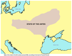
State of the Antes in the 6th century (around 560), according to the book of Francis Dvornik
|

|
White Croatia in the 6th century (around 560), according to the book of Francis Dvornik
|

|
Map of the Western (purple) and Eastern (blue) Gokturk khaganates at their height, c. 600 CE. Lighter areas show direct rule; darker areas show spheres of influence.
|
| [[|border|251x400px]]
|
Territory of Slavic peoples (6th century).
|

|
European territory inahibted by East Slavic tribes in 8th and 9th century.
|

|
Map showing Scandinavian settlement in the eighth (dark red), ninth (red), tenth (orange) and eleventh (yellow) centuries. Areas denoted in green are those affected by frequent viking incursions but with little or no Scandinavian settlement.
|

|
Khazar fall
|

|
Russia 9th-14th Century (Russian)
|

|
Kievan Rus
|

|
Kievan Rus 9th Century
|

|
Kievan Rus 11th Century
|

|
Kievan Rus 13th Century
|

|
Principalities of Kievan Rus' (1054-1132).
|

|
The Kingdom of Galicia–Volhynia (1245-1349)
|

|
Grand Duchy of Lithuania, Rus' (Ukraine) and Samogitia (1386-1434).
|

|
Early Rus'
|

|
Varangian routes
|

|
Map showing changes in borders of the Mongol Empire from founding by Genghis Khan in 1206, Genghis Khan's death in 1227 to the rule of Kublai Khan (1260–1294). (Uses modern day borders)
By 1294 the empire had split into:
|

|
Halych-Volhynia 12th-14th Century
|

|
Map showing changes in the territory of Lithuania, including parts of Ukraine, from the 13th century to the present day
|

|
Lithuania in the 13th and 15th century
|

|
Map of Lithuania
|

|
In 1386 Poland and Lithuania formed a Polish-Lithuanian personal union, succeeded in 1569 by the Polish-Lithuanian Commonwealth. Large parts of present-day Belarus and Ukraine were part of Poland-Lithuania. This map shows the borders in 1466 except in the south-east (which it is wrong about Principality of Moldavia where wasn't a part of the Polish kingdom but a vassal distinct state, allied with Poland).
|

|
Polish-Lithuanian Commonwealth 1569
|

|
Location of the Polish Lithuanian Commonwealth
|

|
Polish Lithuanian Commonwealth compared with present borders
|

|
Polish Lithuanian Commonwealth
|

|
Polish-Swedish Union 1592-1599
|

|
Commonwealth 1600
|

|
Commonwealth 1635
|

|
Historical map of Polish–Lithuanian–Ruthenian Commonwealth or Commonwealth of Three Nations (1658)
|

|
Commonwealth 1658
|

|
Commonwealth 1686
|

|
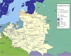
Commonwealth, division in voivodships
|

|
Commonwealth 1701
|

|
Commonwealth 1701
|
| [[|border|251x400px]]
|
Sech in the 18th century
|

|
Ukraine in 1727-1768
|

|
Historical map of Ukrainian Cossack Hetmanate and territory of Zaporozhian Cossacks under rule of Russian Empire (1751).
|

|
Location map of New Serbia (1752-1764) and Slavo-Serbia (1753-1764)
|

|
Location map of New Serbia (1752-1764)
|

|
Detailed map of New Serbia (1752-1764)
|

|
Location map of Slavo-Serbia (1753-1764)
|

|
Detailed map of Slavo-Serbia (1753-1764)
|

|
7 years war 1756-1762
|

|
The divisions of the Commonwealth
|

|
Commonwealth after 1st partition
|

|
Polish-Russian War 1792
|

|
Commonwealth after 2nd partition
|

|
Poland 1794
|

|
The third partition meant the end of the Polish-Lithuanian Commonwealth and the final division between Prussia, Russia and Austria after 3rd partition
|

|
Administrative division of Russia 1848-1878 (in Russian)
|
| [[|border|251x400px]]
|
Ukraine in the Russian Empire
|

|
Historic traditional regions in the present Ukraine
|

|
The Russian Empire in 1914
|

|
History of the Russian Empire (in German)
|

|
Kingdom of Galicia
|

|
Kingdom of Galicia
|

|
Austria-Hungary in 1914
|

|
West Ukrainian People's Republic 1918
|

|
West Ukrainian People's Republic 1918
|

|
After the Russian revolution, Western Ukraine became part of Poland. A war between Poland and the Soviet Russia started March 1919
|

|
December 1919
|

|
June 1920
|

|
August 1920
|

|
Borders of newly independent Poland after the Peace Treaty of Riga of 1921
|
| [[|border|251x400px]]
|
Frescoe Map of Europe in the hall of the Railway Station of Genève-Cornavin (Switzerland), inaugurated june 25, 1929, with Ukraine painted according with the claims of the Ukainian people's republic Rada (1918)
|

|
In 1922 Ukraine becomes a member republic of the Soviet Union. Western Ukraine is part of Poland.. Location of the USSR
|

|
Evolution of the Soviet Union
|

|
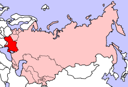
European part of the USSR in the 1920s
|

|
Borders after the Peace Treaty of Riga of 1921 with Western Ukraine in Poland
|

|
Foreign claims in Poland in 1920
|

|
Comparison 1772-1920
|

|
Poland between 1921 and 1939
|

|
Poland Galicia Volynia
|

|
The two Curzon lines : the soviet one (A) and the original one (B)
|

|
Administrative divisions of Ukraine 1918
|

|
Administrative divisions of Ukraine 1921
|

|
Administrative divisions of Ukraine 1921
|

|
Administrative divisions of Ukraine 1927
|

|
Administrative divisions of Ukraine 1932-1937
|
| [[|border|251x400px]]
|
Famine in Ukraine 1921-23 and 1932-1935
|

|
Administrative divisions of Ukraine 1937-1939
|

|
Administrative divisions of Ukraine 1939-1940
|

|
Administrative divisions of Ukraine 1940-1945
|

|
Eastern front of the Second World War circa 1941-1942.
|

|
Changing of the borders
|

|
Border changes after WW2 (Russian text)
|

|
The territorial growth of the modern Ukraine
|

|
Administrative divisions of Ukraine 1946-1954
|

|
The republics of the USSR
|

|
Ukraine in the USSRImage:USSR Ethnic Groups 1974.jpg
|

|
Location of Chernobyl Nuclear Power Plant
|

|
Soviet Union administrative divisions, 1989
|

|
Presidential election runoff vote, 2004
|

|
Parliamentary election, 2006
|

|
Parliamentary election, 2007
|
Linguistic maps

|
Linguistical map of Ukraine
|

|
Languages in Ukraine
|

|
Ukrainian language in Ukraine (2001)
|

|
Map of Ukrainian dialects
|

|
The most numerous ethnic groups in Ukrainian rayons (if the data was available) or oblasts in the year 2001
|

|
Map of Russian speakers in Ukraine, based on the 2001 Ukrainian census
|

|
Romanians in Ukraine (in 1989 and 2001)
|

|
Ethnic map of European Russia before the First World War (in French)
|
Maps of regions
| [[|border|251x400px]]
|
Novorrosiya Region
|
| [[|border|251x400px]]
|
Yedisan Region
|

|
Location of Crimea in Ukraine
|

|
Map of Crimea
|

|
Map of Crimea
|

|
Map of Crimea
|

|
Map of Crimea
|
Ukrainian conflict 1917-1921
| [[|border|251x400px]]
|
Claims of Ukrainian Peoples's Republic
|
| [[|border|251x400px]]
|
Ukraine 1793-1914
|
| [[|border|251x400px]]
|
German conquest and Ukrainian Peoples's Republic and Hetmanate (1918)
|
| [[|border|251x400px]]
|
Supresion of Ukrainian Peoples's Republic, and advance toward Warsaw in Polish-Sovietic war, august 1920
|
| [[|border|251x400px]]
|
Polish attack suported by Ukrainian Peoples's Republic and ocupation of Kiev, 1920 (Soviet-polish war)
|
| [[|border|251x400px]]
|
Territory of Western Ukrainian Repúblic, Red Army's offensive and White forces in March 1919
|
| [[|border|251x400px]]
|
Polish conquest of Western Ukrainian Repúblic, Red Army's offensive, and White forces in March 1920
|
| [[|border|251x400px]]
|
Polish conquest of Western Ukrainian Repúblic, Black Army of Nestor Makhno and White forces offensive in November 1919
|
Notes and references
General remarks:
- The WIKIMEDIA COMMONS Atlas of the World is an organized and commented collection of geographical, political and historical maps available at Wikimedia Commons. The main page is therefore the portal to maps and cartography on Wikimedia. That page contains links to entries by country, continent and by topic as well as general notes and references.
- Every entry has an introduction section in English. If other languages are native and/or official in an entity, introductions in other languages are added in separate sections. The text of the introduction(s) is based on the content of the Wikipedia encyclopedia. For sources of the introduction see therefore the Wikipedia entries linked to. The same goes for the texts in the history sections.
- Historical maps are included in the continent, country and dependency entries.
- The status of various entities is disputed. See the content for the entities concerned.
- The maps of former countries that are more or less continued by a present-day country or had a territory included in only one or two countries are included in the atlas of the present-day country. For example the Ottoman Empire can be found in the Atlas of Turkey.
- ↑ Romanization of Ukrainian according to the official Ukrainian standard: Ukrayina. Another romanization is the ISO 9 standard.
- ↑ Romanization of Ukrainian according to the official Ukrainian standard: Kyyiv. Another romanization is the ISO 9 standard.. For the English translation both Kyiv and Kiev are used.
|
Entries available in the atlas
- General pages
- World
- Continents and oceans
- Themes
- Historical eras
- States with wide recognition
- States with limited recognition
- Dependencies and other overseas territories
- Country subdivisions
- Belgium
- China (mainland)
- India
- Pakistan
- Spain
- United Kingdom
- United States
- Russia
- Other
- Disputed subnational territories
- Other regions
- Cities
- Former sovereign states
- Former dependencies and overseas territories
- Former disputed territories
References
|


