Portal:Maps
| Main page | Maps |
The Maps and Cartography Portal

A map is a symbolic depiction of interrelationships, commonly spatial, between things within a space. A map may be annotated with text and graphics. Like any graphic, a map may be fixed to paper or other durable media, or may be displayed on a transitory medium such as a computer screen. Some maps change interactively. Although maps are commonly used to depict geographic elements, they may represent any space, real or fictional. The subject being mapped may be two-dimensional such as Earth's surface, three-dimensional such as Earth's interior, or from an abstract space of any dimension.
Maps of geographic territory have a very long tradition and have existed from ancient times. The word "map" comes from the medieval Latin: Mappa mundi, wherein mappa meant 'napkin' or 'cloth' and mundi 'of the world'. Thus, "map" became a shortened term referring to a flat representation of Earth's surface. (Full article...)
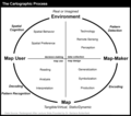
Cartography (/kɑːrˈtɒɡrəfi/; from Ancient Greek: χάρτης chartēs, 'papyrus, sheet of paper, map'; and γράφειν graphein, 'write') is the study and practice of making and using maps. Combining science, aesthetics and technique, cartography builds on the premise that reality (or an imagined reality) can be modeled in ways that communicate spatial information effectively. (Full article...)
Selected article -

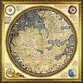
The Fra Mauro map is a map of the world made around 1450 by the Italian (Venetian) cartographer Fra Mauro, which is “considered the greatest memorial of medieval cartography." It is a circular planisphere drawn on parchment and set in a wooden frame that measures over two by two meters. Including Asia, the Indian Ocean, Africa, Europe, and the Atlantic, it is orientated with south at the top. The map is usually on display in the Biblioteca Nazionale Marciana in Venice in Italy.
The Fra Mauro world map is a major cartographical work. It took several years to complete and was very expensive to produce. The map contains hundreds of detailed illustrations and more than 3000 descriptive texts. It was the most detailed and accurate representation of the world that had been produced up until that time. As such, the Fra Mauro map is considered one of the most important works in the history of cartography. According to Jerry Brotton, it marked "the beginning of the end of early medieval mappae mundi that reflected biblical geographical teaching." It placed accuracy ahead of religious or traditional beliefs, breaking with tradition, for example, by not placing Jerusalem at the center of the world and not showing a physical location for the biblical Paradise. (Full article...)
General images -
Selected quote
| “ | The map is not the territory ... The only usefulness of a map depends on similarity of structure between the empirical world and the map... | ” |
| — Alfred Korzybski | ||
Related portals
Related WikiProjects
Selected biography -
Nicolaes Witsen (8 May 1641 – 10 August 1717; Dutch: Nicolaas Witsen) was a Dutch statesman who was mayor of Amsterdam thirteen times, between 1682 and 1706. In 1693, he became administrator of the Dutch East India Company (VOC). In 1689, he was extraordinary-ambassador to the English court and became Fellow of the Royal Society. In his free time, he was cartographer, maritime writer, and an authority on shipbuilding. His books on the subject are important sources on Dutch shipbuilding in the 17th century. Furthermore, he was an expert on Russian affairs. He was the first to describe Siberia, the Far East and Central Asia in his study Noord en Oost Tartarye [North and East Tartary]. (Full article...)
Selected picture

Did you know
- ... that actress Agnes Mapes had to improvise a complex choreographed dance from basic poses for the 1907 play The Holy City?
- ... that DeepStateMap.Live, an interactive map of the Russian invasion of Ukraine, received up to 120,000 visitors in 30 minutes during the Battle of Izium in the 2022 Kharkiv counteroffensive?
- ... that the actress Lottie Williams was one of the cakewalk dancers depicted on the front cover of the sheet music for Scott Joplin's "Maple Leaf Rag"?
- ... that the Canadian League for Peace and Democracy organized a 10,000-person rally at Maple Leaf Gardens in Toronto to protest a 2,500-person fascist rally?
- ... that Kathryn Maple won the Sunday Times Watercolour Competition twice in three years?
- ... that the 100 gecs tree was listed as a "place of worship" on Google Maps?
Topics
Map - Atlas - Geography - Topography
Cartography: Cartographers - History of cartography - Ancient world maps - World maps - Compass rose - Generalization - Geographic coordinate system - Geovisualization - Relief depiction - Scale - Terra incognita - Planetary cartography
Map projection: Azimuthal equidistant - "Butterfly" - Dymaxion - Gall–Peters - General Perspective - Goode homolosine - Mercator - Mollweide - Orthographic - Peirce quincuncial - Robinson - Sinusoidal - Stereographic
Maps: Animated mapping - Cartogram - Choropleth map - Estate map - Geologic map - Linguistic map - Nautical chart - Pictorial map - Reversed map - Road atlas - Thematic map - Topographic map - Weather map - Web mapping - World map
Map examples
World
Historical
Thematic

Geographic

Political

Nautical

Categories
Things you can do
|
Here are some Geography related tasks you can do:
|
Atlases and maps of the world at Wikimedia Commons
Associated Wikimedia
The following Wikimedia Foundation sister projects provide more on this subject:
-
Commons
Free media repository -
Wikibooks
Free textbooks and manuals -
Wikidata
Free knowledge base -
Wikinews
Free-content news -
Wikiquote
Collection of quotations -
Wikisource
Free-content library -
Wikiversity
Free learning tools -
Wiktionary
Dictionary and thesaurus


