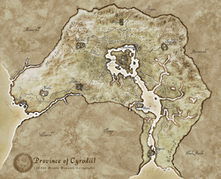
A map showing all the regions of Cyrodiil.
- For other uses, see Regions.
There are a total of ten regions within the province of Cyrodiil. These can vary and each region is unique, as they can be swamps, mountain ranges, coasts, forests, and valleys.
| Name | Type | Description |
|---|---|---|
| Blackwood | Swamps | Blackwood is the great southern swamp that drains the lower Niben River out to Topal Bay. The swamp borders Khajiit Elsweyr on the west and Argonian Black Marsh on the east. |
| Colovian Highlands | Mountains | The Colovian Highlands are Cyrodiil's second floor. They lie in the far northwest of the country, overlooking West Weald and the Imperial Forest. They serve as the rugged frontier between Cyrodiil and Hammerfell. |
| Gold Coast | Coast | The Gold Coast is the western-most region of Cyrodiil. It lies north of the Abecean Sea and stretches from Valenwood to the south to Hammerfell to the north. |
| Great Forest | Forest | The Great Forest is the dense woodland that encircles the Imperial City to its west, north, and south. The Forest serves as a buffer between Colovia and the Empire's capital city. |
| Heartlands | Plains | The Heartlands is a roughly crescent-shaped region, the bulk of which is east and northeast of the Imperial City. The City Isle and the Waterfront are cradled by this region and it nearly stretches all the way around them. It butts into the Great Forest near Fort Homestead. |
| Jerall Mountains | Mountains | The Jerall Mountains are the highest mountains in the Province of Cyrodiil, and straddle most of the northern border. The province of Skyrim lies on other side of the range. This is generally Nord territory. |
| Nibenay Basin | Valley | The Nibenay Basin is perhaps the largest region in all of Cyrodiil, stretching from Cheydinhal to the Panther River, from the foothills of the snowy Jerall Mountains to the swamps of Blackwood. The region also borders the Heartlands and the Nibenay Valley to the west and the Valus Mountains and Black Marsh to the east. |
| Nibenay Valley | Valley | The Nibenay Valley is the name given to the central lowlands along the Niben River south of the Imperial City but north of Blackwood. The valley is a fairly small region, occupying a swath on both sides of the Niben, but hemmed in by the Nibenay Basin, the Great Forest, and the Heartlands. The valley proper begins along the Silverfish River and out to Niben Bay, then south to the lower Panther River. It stretches west past Bravil to the Larsius River where it brushes against the Great Forest. A high ridge between the valley and Lake Canulus marks the eastern border. |
| Valus Mountains | Mountains | The Valus Mountains are a particularly rugged section of the province. The weather is often snowy and visibility is poor. The region is lightly forested with evergreen trees, and hardscrabble brown grass grows year-round. As the range slopes south, however, it becomes more mild and green grasses and deciduous trees can be found in the foothills leading to the Nibenay Basin. |
| West Weald | Grasslands | West Weald is a sunny, lightly-forested region occupying a crescent-shaped arc southwest of the Imperial City, acting as the northern border for the provinces of Elsweyr and Valenwood. This verdant region is notable for its wide-open and purple-flowered meadows, distinctive red maple trees and rich agriculture. |
