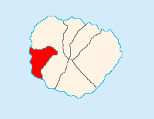
Valle Gran Rey
Valle Gran Rey | |
|---|---|
 Valle Gran Rey | |
 Municipal location in La Gomera | |
| Coordinates: 28°6′N 17°20′W / 28.100°N 17.333°W | |
| Country | |
| Autonomous Region | Canary Islands |
| Province | Santa Cruz de Tenerife |
| Island | La Gomera |
| Government | |
| • Mayor | Angel Piñero Cruz |
| Area | |
• Total | 32.36 km2 (12.49 sq mi) |
| Population (2018)[2] | |
• Total | 4,484 |
| • Density | 140/km2 (360/sq mi) |
| Time zone | UTC+0 (GMT) |
| Website | www.vallegranrey.es |


Valle Gran Rey is a municipality in the western part of the island La Gomera, in the province of Santa Cruz de Tenerife of the Canary Islands, Spain. The Guanche name of the area was Orone.[3] The seat of the municipality since 1930 is La Calera; previously it was in Arure.
The population was 4,240 in 2013,[4] and the area is 32.36 square kilometres (12.49 sq mi).[1] Valle Gran Rey borders the municipality of Vallehermoso to the east, while the Atlantic Ocean lies to the west.
Geography and climate
[edit]It is located in the west of the island, bordering the municipality of Vallehermoso. It has an extension of 32.36 km2 (12½ sq. mi.).[5] The altitude of the municipal capital is about 50 meters (200') above sea level, reaching a maximum altitude of 1,225 meters (4020') above sea level at the central summit of the island.[6]
Valle Gran Rey has a hot-summer Mediterranean climate (Köppen: Csb; Trewartha: Csal), depending on the altitude and location of the nearest weather station in Arure, the precipitation is three to four times higher than in coastal areas due to its location on the windward slope.
| Climate data for Valle Gran Rey (Arure) Climate ID: C316I; coordinates 28°07′42″N 17°18′54″W / 28.12833°N 17.31500°W; elevation: 916 m (3,005 ft); 2018–2024 normals, extremes 2018–present[7] | |||||||||||||
|---|---|---|---|---|---|---|---|---|---|---|---|---|---|
| Month | Jan | Feb | Mar | Apr | May | Jun | Jul | Aug | Sep | Oct | Nov | Dec | Year |
| Record high °C (°F) | 24.5 (76.1) |
26.4 (79.5) |
30.9 (87.6) |
32.4 (90.3) |
34.8 (94.6) |
36.8 (98.2) |
40.0 (104.0) |
42.1 (107.8) |
36.2 (97.2) |
36.5 (97.7) |
29.3 (84.7) |
24.9 (76.8) |
42.1 (107.8) |
| Mean daily maximum °C (°F) | 15.5 (59.9) |
17.1 (62.8) |
17.0 (62.6) |
18.3 (64.9) |
20.5 (68.9) |
22.1 (71.8) |
27.5 (81.5) |
28.9 (84.0) |
25.0 (77.0) |
23.1 (73.6) |
19.3 (66.7) |
17.4 (63.3) |
21.0 (69.8) |
| Daily mean °C (°F) | 12.5 (54.5) |
13.6 (56.5) |
13.6 (56.5) |
14.3 (57.7) |
16.2 (61.2) |
17.8 (64.0) |
22.2 (72.0) |
23.8 (74.8) |
20.6 (69.1) |
19.3 (66.7) |
16.0 (60.8) |
14.3 (57.7) |
17.0 (62.6) |
| Mean daily minimum °C (°F) | 9.4 (48.9) |
10.1 (50.2) |
10.1 (50.2) |
10.3 (50.5) |
11.8 (53.2) |
13.5 (56.3) |
17.0 (62.6) |
18.8 (65.8) |
16.1 (61.0) |
15.4 (59.7) |
12.7 (54.9) |
11.2 (52.2) |
13.0 (55.4) |
| Record low °C (°F) | 5.4 (41.7) |
4.7 (40.5) |
5.7 (42.3) |
7.3 (45.1) |
8.0 (46.4) |
9.9 (49.8) |
11.8 (53.2) |
12.6 (54.7) |
12.4 (54.3) |
9.9 (49.8) |
8.2 (46.8) |
7.8 (46.0) |
4.7 (40.5) |
| Average precipitation mm (inches) | 58.6 (2.31) |
53.4 (2.10) |
50.0 (1.97) |
26.0 (1.02) |
6.6 (0.26) |
12.9 (0.51) |
1.0 (0.04) |
3.7 (0.15) |
17.1 (0.67) |
28.4 (1.12) |
55.8 (2.20) |
57.5 (2.26) |
370.8 (14.60) |
| Average precipitation days (≥ 0.1 mm) | 12.00 | 9.80 | 12.00 | 6.40 | 3.60 | 4.60 | 2.20 | 1.60 | 4.33 | 9.33 | 11.17 | 11.50 | 88.53 |
| Average relative humidity (%) | 71 | 63 | 74 | 75 | 68 | 71 | 49 | 45 | 66 | 68 | 73 | 71 | 66 |
| Source: State Meteorological Agency/AEMET OpenData[8][9] | |||||||||||||
Subdivisions
[edit]- Arure
- La Calera (seat)
- Casa de la Seda
- El Guro
- Las Hayas
- El Hornillo
- Taguluche
- La Playa
- Vueltas
Historical population
[edit]| Year | Population |
|---|---|
| 1991 | 3,103 |
| 1996 | 3,631 |
| 2001 | 4,238 |
| 2002 | 4,248 |
| 2003 | 4,487 |
| 2004 | 4,745 |
| 2005 | 4,857 |
| 2013 | 4,240 |
Notable natives and residents
[edit]- Tim Hart (died 2009), English folk musician
- Oliver Weber, German photographer, physician and professor of visual arts
See also
[edit]References
[edit]- ^ a b Instituto Canario de Estadística, area
- ^ Municipal Register of Spain 2018. National Statistics Institute.
- ^ Asociación Canaria para la Enseñanza de las Ciencias "Viera y Clavijo" (October 2009). "cursos: "Ecosistemas gomeros"". Retrieved 2010-02-10.
- ^ Instituto Canario de Estadística, population
- ^ Instituto Nacional de Estadística. "Población, superficie y densidad por municipios". Archived from the original on 7 March 2016.
- ^ Consejería de Educación, Universidades y Sostenibilidad. Gobierno de Canarias. "Mapa Topográfico Integrado". Infraestructura de Datos Espaciales de Canarias.
- ^ "Weather station data". opendata.aemet.es (in Spanish). AEMET OpenData. Archived from the original on 2024-11-13. Retrieved 13 November 2024.
- ^ "Extremes". opendata.aemet.es (in Spanish). AEMET OpenData. Archived from the original on 2024-12-04. Retrieved 6 December 2024.
- ^ "AEMET OpeenData". Agencia Estatal de Meteorologia. Retrieved 2024-11-13.
External links
[edit]- (in Spanish) Website Valle Gran Rey
- Blog La Gomera


