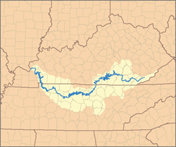
แม่น้ำคัมเบอร์แลนด์
หน้าตา
| แม่น้ำคัมเบอร์แลนด์ | |
| ประเทศ | สหรัฐอเมริกา |
|---|---|
| รัฐ | รัฐเคนทักกี, รัฐเทนเนสซี |
| แม่น้ำสาขา | |
| - ซ้าย | Martin's Fork, Clear Fork, Big South Fork, Obey River, Caney Fork, Stones River, Harpeth River |
| - ขวา | Clover Fork, Poor Fork, Laurel River, Rockcastle River, Red River, Little River |
| เมือง | Williamsburg, KY, Burkesville, KY, Carthage, TN, Nashville, TN, Clarksville, TN, Dover, TN |
| ต้นกำเนิด | Confluence of Clover Fork and Martins Fork |
| - ตำแหน่ง | Baxter, Kentucky |
| - ระดับ | |
| ปากแม่น้ำ | Ohio River |
| - ตำแหน่ง | Livingston County, Kentucky |
| - ระดับ | |
| ความยาว | 688 mi (1,107 km) [1] |
| พื้นที่ลุ่มน้ำ | 17,728 ตร.ไมล์ (45,915 ตร.กม.) [2] |
| การไหล | for below Barkley Dam, about 31 mi (50 km) from the mouth |
| - เฉลี่ย | 37,250 cu ft/s (1,055 m3/s) [3] |
| - สูงสุด | 209,000 cu ft/s (5,918 m3/s) |
| - ต่ำสุด | 6,085 cu ft/s (172 m3/s) |
แม่น้ำคัมเบอร์แลนด์ (อังกฤษ: Cumberland River) เป็นแม่น้ำสายใหญ่ทางตอนใต้ของสหรัฐอเมริกา มีความยาว 688 ไมล์ (1,107 กม.)[1] มีพื้นที่ระบายน้ำเกือบ 18,000 ตร.ไมล์ (47,000 ตร.กม.) ผ่านทางใต้ของรัฐเคนทักกี และทางเหนือ-กลาง ของรัฐเทนเนสซี แม่น้ำไหลไปทางทิศตะวันตก โดยต้นน้ำอยู่ในเทือกเขาแอปพาเลเชียน ไหลลงแม่น้ำโอไฮโอ ใกล้เมืองแพดูคาห์ ในรัฐเคนทักกี และปากแม่น้ำเทนเนสซี
อ้างอิง
[แก้]- ↑ 1.0 1.1 U.S. Geological Survey. National Hydrography Dataset high-resolution flowline data. The National Map เก็บถาวร 2012-03-29 ที่ เวย์แบ็กแมชชีน, accessed June 8, 2011
- ↑ "Boundary Descriptions and Names of Regions, Subregions, Accounting Units and Cataloging Units". United States Geological Survey. สืบค้นเมื่อ 2013-11-09.
- ↑ "USGS Gage #03438220 on the Cumberland River near Grand Rivers, KY". National Water Information System. U.S. Geological Survey. 1965–1997. สืบค้นเมื่อ 2013-11-09.


