Waldershof
Appearance
Waldershof | |
|---|---|
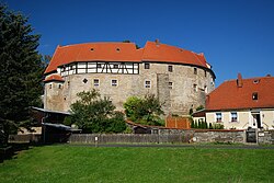
 Ganerbenburg Castle in Waldershof | |
| Coordinates: 49°58′N 12°4′E / 49.967°N 12.067°E | |
| Country | Germany |
| State | Bavaria |
| Admin. region | Oberpfalz |
| District | Tirschenreuth |
| Subdivisions | 26 Ortsteile |
| Government | |
| • Mayor (2020–26) | Margit Bayer[1] (CSU) |
| Area | |
| • Total | 60.40 km2 (23.32 sq mi) |
| Elevation | 546 m (1,791 ft) |
| Population (2022-12-31)[2] | |
| • Total | 4,212 |
| • Density | 70/km2 (180/sq mi) |
| Time zone | UTC+01:00 (CET) |
| • Summer (DST) | UTC+02:00 (CEST) |
| Postal codes | 95679 |
| Dialling codes | 09231 |
| Vehicle registration | TIR |
| Website | www.waldershof.de |
Waldershof is a town in Tirschenreuth, in Bavaria, Germany. It is 22 km northwest of Tirschenreuth, and 3 km southwest of Marktredwitz.
Geography
[change | change source]The 60 square kilometer City of Waldershof is bounded on the North by the City of Marktredwitz. The boundary line between the two cities is also the border for the counties of Tirschenreuth and Wunsiedel as well as the regional zones of the Upper Palatinate and Upper Franconia.
Literature
[change | change source]Zeitler, Walther. (Ed.). (1988). Heimatbuch der Stadt Waldershof. Amberg, Bavaria, Germany: Vereinigte Oberpfaelzische Druckereien und Verlagsanstalt Gmbh, Translated by: Walter Swett
References
[change | change source]- ↑ Liste der ersten Bürgermeister/Oberbürgermeister in kreisangehörigen Gemeinden, Bayerisches Landesamt für Statistik, 15 July 2021.
- ↑ Genesis Online-Datenbank des Bayerischen Landesamtes für Statistik Tabelle 12411-003r Fortschreibung des Bevölkerungsstandes: Gemeinden, Stichtag (Einwohnerzahlen auf Grundlage des Zensus 2011) .


