Sancerre
Appearance
Sancerre | |
|---|---|
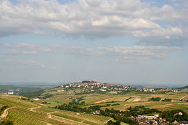
 A general view of Sancerre | |
| Coordinates: 47°19′55″N 2°50′24″E / 47.332°N 2.840°E | |
| Country | France |
| Region | Centre-Val de Loire |
| Department | Cher |
| Arrondissement | Bourges |
| Canton | Sancerre |
| Intercommunality | CC Pays Fort Sancerrois Val de Loire |
| Government | |
| • Mayor (2020–2026) | Laurent Pabiot[1] |
| Area 1 | 16.27 km2 (6.28 sq mi) |
| Population (Jan. 2019)[2] | 1,349 |
| • Density | 83/km2 (210/sq mi) |
| Time zone | UTC+01:00 (CET) |
| • Summer (DST) | UTC+02:00 (CEST) |
| INSEE/Postal code | 18241 /18300 |
| Elevation | 146–366 m (479–1,201 ft) (avg. 310 m or 1,020 ft) |
| 1 French Land Register data, which excludes lakes, ponds, glaciers > 1 km2 (0.386 sq mi or 247 acres) and river estuaries. | |
Sancerre is a medieval hilltop town and commune in the Cher department, France overlooking the river Loire. It is noted for its wine.
It is a natural fortress 312 meters in height. The Counts of Champagne built fortifications there in the 12th century. During the French Wars of Religion the Huguenot people were besieged there for 8 months in 1572/3. About 500 people died, mostly of starvation. The siege of Sancerre was written about by a Protestant minister Jean de Léry, who survived the battle, in The Memorable History of the Siege of Sancerre (1574). A mansion was built on the ruins of the original Chateau de Sancerre in 1874.
In 2008 there were 1697 people living there. [3]
References
[change | change source]- ↑ "Répertoire national des élus: les maires" (in French). data.gouv.fr, Plateforme ouverte des données publiques françaises. 13 September 2022.
- ↑ "Populations légales 2019". The National Institute of Statistics and Economic Studies. 29 December 2021.
- ↑ "SANCERRE - Map of Sancerre 18300 France". www.map-france.com. Retrieved 2023-04-10.


