Mariposa, California
Appearance
Mariposa | |
|---|---|
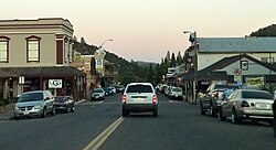
 Dusk in downtown Mariposa | |
 Location in Mariposa County and the state of California | |
| Coordinates: 37°29′06″N 119°57′59″W / 37.48500°N 119.96639°W | |
| Country | |
| State | |
| County | |
| Area | |
| • Total | 4.040 sq mi (10.46 km2) |
| • Land | 4.037 sq mi (10.46 km2) |
| • Water | 0.003 sq mi (0.008 km2) 0.07% |
| Elevation | 1,949 ft (594 m) |
| Population (2020)[3] | |
| • Total | 1,526 |
| • Density | 378.0/sq mi (145.9/km2) |
| Time zone | UTC-8 (Pacific Time Zone) |
| • Summer (DST) | UTC-7 (PDT) |
| ZIP code | 95338 |
| Area code | 209 |
| FIPS code | 06-45932 |
| GNIS feature IDs | 1659063,[4] 2408181[5] |
Mariposa (formerly Agua Fria) is a census-designated place (CDP) of California in the United States. It is the county seat of Mariposa County.
References
[change | change source]- ↑ "2021 U.S. Gazetteer Files: California". United States Census Bureau. Retrieved July 26, 2022.
- ↑ U.S. Geological Survey Geographic Names Information System: Mariposa, California
- ↑ "P1. Race – Mariposa CDP, California: 2020 DEC Redistricting Data (PL 94-171)". U.S. Census Bureau. Retrieved July 26, 2022.
- ↑ U.S. Geological Survey Geographic Names Information System: Mariposa
- ↑ U.S. Geological Survey Geographic Names Information System: Mariposa Census Designated Place


