Khabarovsk
Khabarovsk
Хабаровск | |
|---|---|
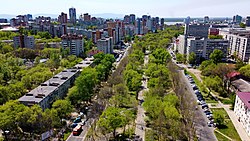
 View of Khabarovsk looking down the Ussuriysky Boulevard | |
| Anthem: Anthem of Khabarovsk[2] | |
| Coordinates: 48°29′N 135°05′E / 48.483°N 135.083°E | |
| Country | Russia |
| Federal subject | Khabarovsk Krai[3] |
| Founded | May 31, 1858[4] |
| City status since | 1880[5] |
| Government | |
| • Body | City Duma[6] |
| • Mayor[6] | Sergei Kravchuk[7] |
| Area | |
| • Total | 400 km2 (200 sq mi) |
| Elevation | 72 m (236 ft) |
| Population | |
| • Total | 577,441 |
| • Estimate (January 2015)[10] | 607,216 |
| • Rank | 26th in 2010 |
| • Density | 1,400/km2 (3,700/sq mi) |
| • Subordinated to | city of krai significance of Khabarovsk[1] |
| • Capital of | Khabarovsk Krai[3], city of krai significance of Khabarovsk[11] |
| • Urban okrug | Khabarovsk Urban Okrug[12] |
| • Capital of | Khabarovsk Urban Okrug[12], Khabarovsky Municipal District[13] |
| Time zone | UTC+10 (MSK+7 |
| Postal code(s)[15] | 680000–680003, 680006, 680007, 680009, 680011–680015, 680017, 680018, 680020–680023, 680025, 680026, 680028–680033, 680035, 680038, 680040–680043, 680045, 680047, 680051, 680052, 680054, 680055, 680700, 680880, 680890, 680899, 680921, 680950, 680960–680967, 680970, 680999, 901183, 901185 |
| Dialing code(s) | +7 4212 |
| OKTMO ID | 08701000001 |
| City Day | Last Sunday of May[4] |
| Twin towns | Villeurbanne, Niigata, Portland, Victoria, Harbin, Bucheon, Sanya, Chongjin, Mudanjiang, Haikou, Musashino |
| Website | khabarovskadm |
Khabarovsk (Russian: Хабаровск) is a city in and the administrative center of Khabarovsk Krai, Russia. It has 618,150 people as of 2018.
History
[change | change source]Khabarovsk is located at the Amur River just below the city's confluence with the Ussuri. Khabarovsk was named after E.P. Khabarov, who made several undertaken journeys to the Amur River basin in the mid-17th century. Khabarovsk was founded in May 31,1858 as a military outpost. Khabarovsk's nodal position at the point at which the Trans-Siberian Railway crosses the Amur River made it an important focus of the Russian Far East, and at one time it administered the entire area to the Bering Strait, which connects Russia and North America. Modern Khabarovsk spreads across a series of small valleys and ridges perpendicular to the Amur.
Khabarovsk has an attractive waterfront park and long area and a mixture of modern apartment blocks, factories, and old, one-story wooden houses. It is a major industrial centre, with most enterprises located in the upstream district. They include large scale engineering and machine-building industries, oil refining, timber working, furniture making, and many light industries.
Economy
[change | change source]Khabarovsk has an institution of higher education, agricultural, medical, teacher-training, and railway-engineering institutes and several scientific-research establishments.
References
[change | change source]- ↑ 1.0 1.1 Resolution #143-pr
- ↑ Decision #856
- ↑ 3.0 3.1 Law #109
- ↑ 4.0 4.1 Charter of Khabarovsk, Article 2
- ↑ Энциклопедия Города России. Moscow: Большая Российская Энциклопедия. 2003. p. 503. ISBN 5-7107-7399-9.
- ↑ 6.0 6.1 Charter of Khabarovsk, Article 19
- ↑ Official website of Khabarovsk. Sergei Anatolyevich Kravchuk Archived 2020-12-10 at the Wayback Machine, Mayor of Khabarovsk (in Russian)
- ↑ Official website of Khabarovsk. Brief Reference Archived 2016-03-04 at the Wayback Machine (in Russian)
- ↑ Всероссийская перепись населения 2010 года. Том 1 [2010 All-Russian Population Census, vol. 1]. Всероссийская перепись населения 2010 года (2010 All-Russia Population Census) (in Russian). Federal State Statistics Service. 2011. Retrieved June 29, 2012.
- ↑ Khabarovsk Krai Territorial Branch of the Federal State Statistics Service. Численность населения Хабаровского края по муниципальным образованиям на 1 января 2015 года Archived March 5, 2016, at the Wayback Machine (in Russian)
- ↑ Государственный комитет Российской Федерации по статистике. Комитет Российской Федерации по стандартизации, метрологии и сертификации. №ОК 019-95 1 января 1997 г. «Общероссийский классификатор объектов административно-территориального деления. Код 08 401», в ред. изменения №278/2015 от 1 января 2016 г.. (State Statistics Committee of the Russian Federation. Committee of the Russian Federation on Standardization, Metrology, and Certification. #OK 019-95 January 1, 1997 Russian Classification of Objects of Administrative Division (OKATO). Code 08 401, as amended by the Amendment #278/2015 of January 1, 2016. ).
- ↑ 12.0 12.1 Law #177
- ↑ Law #264
- ↑ "Об исчислении времени". Официальный интернет-портал правовой информации (in Russian). 3 June 2011. Retrieved 19 January 2019.
- ↑ Почта России. Информационно-вычислительный центр ОАСУ РПО. (Russian Post). Поиск объектов почтовой связи (Postal Objects Search) (in Russian)


