Inzell
Appearance
Inzell | |
|---|---|
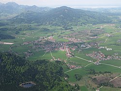
 Inzell from the southeast | |
| Coordinates: 47°45′45″N 12°44′57″E / 47.76250°N 12.74917°E | |
| Country | Germany |
| State | Bavaria |
| Admin. region | Oberbayern |
| District | Traunstein |
| Government | |
| • Mayor (2020–26) | Johann Egger[1] |
| Area | |
| • Total | 45.35 km2 (17.51 sq mi) |
| Elevation | 693 m (2,274 ft) |
| Population (2022-12-31)[2] | |
| • Total | 4,911 |
| • Density | 110/km2 (280/sq mi) |
| Time zone | UTC+01:00 (CET) |
| • Summer (DST) | UTC+02:00 (CEST) |
| Postal codes | 83334 |
| Dialling codes | 08665 |
| Vehicle registration | TS |
| Website | www.inzell.de |
Inzell is a municipality in Traunstein in Bavaria, Germany.
Geography
[change | change source]Inzell is in a wide valley floor in the Chiemgau Alps, enclosed by the mountains of Rauschberg, Zinnkopf, Teisenberg and the range of Staufen. In the municipality, the convergence of the Großwaldbach and Falkenseebach rivers forms the Rote Traun river.[3] Inzell is also known as the gateway to Berchtesgaden National Park due to the Zwing, a mountain passage between Inzell and Weißbach, which separates the Chiemgau from Berchtesgaden.[3]
References
[change | change source]- ↑ Liste der ersten Bürgermeister/Oberbürgermeister in kreisangehörigen Gemeinden, Bayerisches Landesamt für Statistik, 15 July 2021.
- ↑ Genesis Online-Datenbank des Bayerischen Landesamtes für Statistik Tabelle 12411-003r Fortschreibung des Bevölkerungsstandes: Gemeinden, Stichtag (Einwohnerzahlen auf Grundlage des Zensus 2011) .
- ↑ 3.0 3.1 "Inzell". LAG Chiemgauer Alpen (in German). Archived from the original on 12 July 2015. Retrieved 2 February 2015.
Other websites
[change | change source]Wikimedia Commons has media related to Inzell.
Wikivoyage has a travel guide about: Inzell


