Enugu
Appearance
Enugu
Énugwú | |
|---|---|
City | |
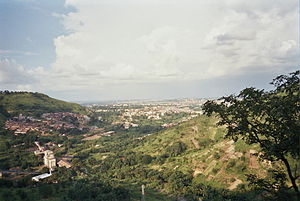
 August 2006 view of Enugu from the hills on the west side of the city | |
| Nicknames: Coal City, Capital of Igboland | |
| Coordinates: 6°27′10″N 7°30′40″E / 6.45278°N 7.51111°E | |
| Country | Nigeria |
| State | Enugu |
| LGA | Enugu East, Enugu North, Enugu South |
| Incorporated | in 1909 |
| Founded by | Enugwu-Ngwo and Ogui Nike people |
| Named for | its hilly geography |
| Government | |
| • Type | Executive Chairman-Council |
| • Governing body | Local Government Council |
| • Party | PDP |
| • Chairman | Emeka Nnamani (Enugu North); Paul Ogbe (Enugu South Urban); Theresa Egbo (Enugu South Rural); Christopher Ugwu (Enugu East) |
| Area | |
| • Total | 556 km2 (215 sq mi) |
| Elevation | 180 m (590 ft) |
| Population (2006 census)[3] | |
| • Total | 722,664 |
| • Rank | 9th |
| • Density | 1,300/km2 (3,400/sq mi) |
| Time zone | UTC+1 (WAT) |
| Postcode | 400...[4] |
| Area code | 042[5] |
| Climate | Aw |
| Website | http://www.enugustate.gov.ng/ |
Enugu (/eɪˈnuːɡuː/ (![]() listen) ay-NOO-goo;[6] Igbo: Énugwú)[7][8] is the capital of Enugu State in Nigeria. It is located in southeastern Nigeria. The city had a population of 722,664 in 2006.
listen) ay-NOO-goo;[6] Igbo: Énugwú)[7][8] is the capital of Enugu State in Nigeria. It is located in southeastern Nigeria. The city had a population of 722,664 in 2006.
References
[change | change source]- ↑ "Enugu State Population". CityPopulation.
- ↑ Duckworth, Edward Harland (1961). "Enugu-Coal Town". Nigeria Magazine (70). Nigeria. Federal Ministry of Information. Cultural Division: 251.
- ↑ "FEDERAL REPUBLIC OF NIGERIA : 2006 Population Census" (PDF). Archived from the original (PDF) on 5 March 2012. Retrieved 25 July 2016.
- ↑ "Nipost Postcode Map". Nigerian Postal Service. Archived from the original on 2009-10-07. Retrieved 2010-05-08.
- ↑ Williams, p. 87.
- ↑ Enugu (Dictionary.com Unabridged ed.), Random House, Inc., retrieved 2010-06-12
- ↑ Garry, Jane; Rubino, Carl R. Galvez (2001). Facts about the world's languages: an encyclopedia of the world's major languages, past and present. H.W. Wilson. p. 328. ISBN 978-0-8242-0970-4.
- ↑ Egbokhare, Francis O.; Oyetade, S. Oluwole (2002). Harmonization and standardization of Nigerian languages. CASAS. p. 106. ISBN 978-1-919799-70-4.

