Prague 19
Appearance
Prague 19
Praha 19 | |
|---|---|
Municipal District of Prague Administrative District of Prague | |
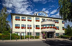
 Prague 19 town hall | |
 Location of Prague 19 in Prague | |
| Coordinates: 50°8′0���N 14°32′58″E / 50.13333°N 14.54944°E | |
| Country | Czech Republic |
| Region | Prague |
| Government | |
| • Mayor | Pavel Žďárský |
| Area | |
| • Total | 5.99 km2 (2.31 sq mi) |
| Population (2021) | |
| • Total | 7,216 |
| • Density | 1,200/km2 (3,100/sq mi) |
| Time zone | UTC+1 (CET) |
| • Summer (DST) | UTC+2 (CEST) |
| Postal code | 197 00 |
| Website | http://www.praha19.cz |
Prague 19, also known as Kbely (German: Gbel), is a municipal district (městská část) in Prague. It is located in the north-eastern part of the city. It is formed by one cadastre, Kbely. As of 2008[update], there were 6,149 inhabitants living in Prague 19.
The administrative district (správní obvod) of the same name consists of municipal districts Prague 19, Satalice and Vinoř.

Climate
[edit]| Climate data for Kbely (1991−2020) | |||||||||||||
|---|---|---|---|---|---|---|---|---|---|---|---|---|---|
| Month | Jan | Feb | Mar | Apr | May | Jun | Jul | Aug | Sep | Oct | Nov | Dec | Year |
| Record high °C (°F) | 17.0 (62.6) |
18.5 (65.3) |
22.4 (72.3) |
30.2 (86.4) |
31.2 (88.2) |
37.0 (98.6) |
36.7 (98.1) |
38.0 (100.4) |
32.9 (91.2) |
26.1 (79.0) |
18.9 (66.0) |
14.1 (57.4) |
38.0 (100.4) |
| Mean daily maximum °C (°F) | 2.3 (36.1) |
4.1 (39.4) |
8.7 (47.7) |
14.9 (58.8) |
19.4 (66.9) |
22.5 (72.5) |
24.8 (76.6) |
24.8 (76.6) |
19.4 (66.9) |
13.2 (55.8) |
7.0 (44.6) |
3.2 (37.8) |
13.7 (56.6) |
| Daily mean °C (°F) | −0.1 (31.8) |
1.0 (33.8) |
4.6 (40.3) |
9.9 (49.8) |
14.3 (57.7) |
17.8 (64.0) |
19.8 (67.6) |
19.4 (66.9) |
14.6 (58.3) |
9.3 (48.7) |
4.4 (39.9) |
0.9 (33.6) |
9.7 (49.4) |
| Mean daily minimum °C (°F) | −3.0 (26.6) |
−2.5 (27.5) |
0.4 (32.7) |
4.3 (39.7) |
8.8 (47.8) |
12.4 (54.3) |
14.3 (57.7) |
13.9 (57.0) |
9.7 (49.5) |
5.4 (41.7) |
1.5 (34.7) |
−1.8 (28.8) |
5.3 (41.5) |
| Record low °C (°F) | −23.1 (−9.6) |
−20.9 (−5.6) |
−15.7 (3.7) |
−7.2 (19.0) |
−2.1 (28.2) |
2.6 (36.7) |
7.0 (44.6) |
5.1 (41.2) |
0.5 (32.9) |
−7.5 (18.5) |
−11.7 (10.9) |
−22.8 (−9.0) |
−23.1 (−9.6) |
| Average precipitation mm (inches) | 22.3 (0.88) |
21.3 (0.84) |
31.3 (1.23) |
26.7 (1.05) |
59.5 (2.34) |
70.5 (2.78) |
70.1 (2.76) |
64.9 (2.56) |
45.1 (1.78) |
34.2 (1.35) |
30.8 (1.21) |
29.0 (1.14) |
505.7 (19.92) |
| Average precipitation days (≥ 1.0 mm) | 6.8 | 5.8 | 7.8 | 6.5 | 9.2 | 9.5 | 9.2 | 8.8 | 6.9 | 7.3 | 7.2 | 6.7 | 91.7 |
| Mean monthly sunshine hours | 47.3 | 77.9 | 120.9 | 187.8 | 224 | 232.3 | 242.4 | 231 | 161.7 | 104.1 | 49.6 | 41.8 | 1,720.8 |
| Source: NOAA[1] | |||||||||||||
Demographics
[edit]| Year | Pop. | ±% |
|---|---|---|
| 1869 | 677 | — |
| 1880 | 898 | +32.6% |
| 1890 | 1,054 | +17.4% |
| 1900 | 1,322 | +25.4% |
| 1910 | 1,518 | +14.8% |
| 1921 | 1,765 | +16.3% |
| 1930 | 5,546 | +214.2% |
| 1950 | 5,884 | +6.1% |
| 1961 | 6,929 | +17.8% |
| 1970 | 6,698 | −3.3% |
| 1980 | 5,688 | −15.1% |
| 1991 | 4,669 | −17.9% |
| 2001 | 4,592 | −1.6% |
| 2011 | 6,768 | +47.4% |
| 2021 | 7,216 | +6.6% |
| Source: Censuses[2][3] | ||
See also
[edit]References
[edit]- ^ "Climate Normals for 1991-2020: Praha (Kbely)" (CSV). National Oceanic and Atmospheric Administration. Retrieved 2 April 2024.
WMO number: 11567
- ^ "Historický lexikon obcí České republiky 1869–2011 – Praha" (in Czech). Czech Statistical Office. 2015-12-21. pp. 7–8.
- ^ "Population Census 2021: Population by sex". Public Database. Czech Statistical Office. 2021-03-27.
External links
[edit]


