Pluvigner
Pluvigner
Pleuwigner | |
|---|---|
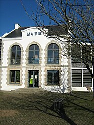
 The town hall in Pluvigner | |
| Coordinates: 47°46′00″N 3°01′00″W / 47.7667°N 3.0167°W | |
| Country | France |
| Region | Brittany |
| Department | Morbihan |
| Arrondissement | Lorient |
| Canton | Pluvigner |
| Intercommunality | Auray Quiberon Terre Atlantique |
| Government | |
| • Mayor (2020–2026) | Diane Hingray[1] |
| Area 1 | 82.83 km2 (31.98 sq mi) |
| Population (2021)[2] | 7,651 |
| • Density | 92/km2 (240/sq mi) |
| Time zone | UTC+01:00 (CET) |
| • Summer (DST) | UTC+02:00 (CEST) |
| INSEE/Postal code | 56177 /56330 |
| Elevation | 17–146 m (56–479 ft) |
| 1 French Land Register data, which excludes lakes, ponds, glaciers > 1 km2 (0.386 sq mi or 247 acres) and river estuaries. | |
Pluvigner (French pronunciation: [plyviɲe]; Breton: Pleuwigner) is a commune in the Morbihan department of Brittany in north-western France.[3]
Demographics
[edit]Inhabitants of Pluvigner are called in French Pluvignois.
At the 1999 census, the town had a population of 5,428. In 2017 the population was 7,543.[4]
Town centre
[edit]At the centre of Pluvigner is L'Eglise St Guigner, near which two main squares form the principal shopping district. There are three bakeries, two butchers, clothes shops, a post office, a florist and three bars in the centre. A Super U and Lidl supermarket can be found on the outskirts. There is also a sports complex with football and rugby pitches, tennis courts and a gym.
Breton language
[edit]The municipality launched a linguistic plan through Ya d'ar brezhoneg on 9 November 2006.
In 2008, there was 9,66% of the children attended the bilingual schools in primary education.[5]
Modern History
[edit]From 1687 to 1688, violence occurred in Pluvigner against the population of Caquins, supposed descendants of medieval lepers. The people of Pluvigner opposed the authorities who wanted to ban the custom preventing Caquins from burying their dead in the parish cemetery.[6]
The trève of Saint-Bieuzy, which depended under the Ancien Régime on the parish of Pluvigner, became a commune in 1793, but this was incorporated into that of Pluvigner before 1806.[7]
Twin towns
[edit]The town is twinned with Cahirciveen, County Kerry, Ireland ![]() since 1984.[8][9]
since 1984.[8][9]
See also
[edit]References
[edit]- ^ "Maires du Morbihan" (PDF). Préfecture du Morbihan. 7 July 2020.
- ^ "Populations légales 2021" (in French). The National Institute of Statistics and Economic Studies. 28 December 2023.
- ^ INSEE commune file
- ^ Population en historique depuis 1968, INSEE
- ^ (in French) Ofis ar Brezhoneg: Enseignement bilingue
- ^ Alain, Croix (1979). "L'histoire d'un trait de mentalité. Les caquins en Bretagne" [The story of a mental trait. The Caquins in Brittany]. Annales de Bretagne et des pays de l'Ouest (in French). 86 (4): 553–564.
- ^ "Saint-Bieuzy". Notice Communale (in French).
- ^ Association Bretagne-Irlande (in French)
- ^ O’Sullivan, Kathy (9 June 2005). "Women with a mission bring image of Kerry life to France". Irish Independent.
A COMPREHENSIVE pictorial representation of modern rural life in South West Kerry, currently on display in the library in Cahersiveen, will travel to France later this month to go on display in Pluvigner, Cahersiveen's Breton twin.
External links
[edit]- Official website (in French)
- Base Mérimée: Search for heritage in the commune, Ministère français de la Culture. (in French)
- Mayors of Morbihan Association (in French)


