Oakley, Cincinnati
Oakley | |
|---|---|
 Oakley Square | |
 Location within Cincinnati | |
| Coordinates: 39°09′04″N 84°26′00″W / 39.151183°N 84.433245°W | |
| Country | United States |
| State | Ohio |
| County | Hamilton |
| City | Cincinnati |
| Elevation | 600 ft (182.8 m) |
| Population (2020) | |
| • Total | 11,761 |
| Time zone | UTC-5 (EST) |
| • Summer (DST) | UTC-4 (EDT) |
| ZIP code | 45209 |
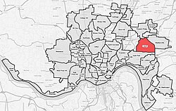
Oakley is one of the 52 neighborhoods of Cincinnati, Ohio. Located in the eastern part of the city, it borders Pleasant Ridge, Madisonville, and Hyde Park. Oakley is a primary thoroughfare and a major crosstown artery in Cincinnati, and contains multiple shopping centers. The population was 11,761 at the 2020 census.[1]
History
[edit]This section needs additional citations for verification. (December 2023) |


The village of Oakley was first established in 1852 when John William and Mary (Vogel) Schrimper opened Schrimpers Tavern, "The Four Mile House". The place was four miles from Cincinnati via "the big road" Madisonville Turnpike. The area was not named Oakley yet and was referred to as Four Mile. Once the Marietta and Cincinnati railroad was built alongside The Four Mile House in 1866, the train stop at the train depot was referred to as Schusterville, which was named after Colonel Paul Schuster, who owned 35 acres of land in that specific area. About the time Schuster's platting of the town, a farm owner named John Wilson laid off more of it on his farm adjoining it. On May 30th 1869, the Schuster and Wilson plats were recorded with Hamilton County as one under the name "Oakley on East Walnut Hills ". The town was named for the Reverend Maurice Oakley, early president of Xavier University (then known as St. Xavier College), for whom both Wilson and Schuster had much admiration. The village was incorporated in 1898.
During the 1880s and 1890s the community began to grow and the Oakley Park Race Track, famous for thoroughbred racing, was opened in 1888. The race track closed in 1907 due to a state law prohibiting betting and a lack of attendance. The Cincinnati Milling Machine Company, often referred to as “the mill,” moved to Oakley in 1905 and library service began in 1910, when a deposit station opened in Barton's Drug Store at 3200 Madison Rd at the corner of Brazee Street.
Oakley was annexed to the city of Cincinnati in 1913.[2] In the same year, Aglamesis Bro's Ice Cream Parlor and Candy Shoppe opened to accommodate the growing population of workers at the Mill, as the Cincinnati Milling Machine Company was called.
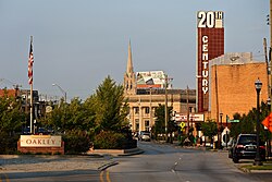
The Geier Esplanade, commonly known as Oakley Square, was created when two parcels of land were acquired in 1927 and 1932 and were converted into green space. It is situated in the center of Oakley Square.
The Twentieth Century Theatre was built in 1941 and is a distinctive Oakley landmark with its 72-foot tower rising over the business district. The deteriorating theater was slated for demolition in the early 1990s, but was spared due to its historical significance and was renovated into a concert and special events venue.
Demographics
[edit]| Year | Pop. | ±% | ||
|---|---|---|---|---|
| 1900 | 1,791 | — | ||
| 1910 | 4,438 | +147.8% | ||
| 1920 | 10,150 | +128.7% | ||
| 1930 | 13,211 | +30.2% | ||
| 1940 | 13,794 | +4.4% | ||
| 1950 | 15,504 | +12.4% | ||
| 1960 | 15,052 | −2.9% | ||
| 1970 | 14,781 | −1.8% | ||
| 1980 | 12,801 | −13.4% | ||
| 1990 | 12,351 | −3.5% | ||
| 2000 | 11,244 | −9.0% | ||
| 2010 | 10,308 | −8.3% | ||
| 2020 | 11,761 | +14.1% | ||
| ||||
| [citation needed] | ||||
As of the census of 2020, there were 11,761 people living in the neighborhood. There were 7,456 housing units. The racial makeup of the neighborhood was 82.0% White, 7.4% Black or African American, 0.2% Native American, 3.8% Asian, 0.0% Pacific Islander, 1.2% from some other race, and 5.5% from two or more races. 3.6% of the population were Hispanic or Latino of any race.[1]
There were 6,561 households, out of which 33.2% were families. 52.3% of all households were made up of individuals.[1]
11.2% of the neighborhood's population were under the age of 18, 76.0% were 18 to 64, and 12.8% were 65 years of age or older. 47.8% of the population were male and 52.2% were female.[1]
According to the U.S. Census American Community Survey, for the period 2016-2020 the estimated median annual income for a household in the neighborhood was $76,568. About 1.5% of family households were living below the poverty line. About 70.5% of adults had a bachelor's degree or higher.[1]
Economy
[edit]This section needs additional citations for verification. (December 2023) |
Oakley's business district, Oakley Square, lies along Madison Road. In addition to Oakley Square, Oakley contains two shopping centers. Hyde Park Plaza on the southern edge of the neighborhood is named for the neighborhood to the south, Hyde Park. The Center of Cincinnati on the north edge is part of continuing development on the south side of the I-71/Norwood Lateral/Ridge Road interchange. Both of these centers are urban infill and car oriented, located on the edge of Oakley and designed to serve multiple neighborhoods. Oakley Square, by contrast, is located in the center of Oakley along several bus routes, making it more pedestrian and transit oriented.
Culture
[edit]The neighborhood hosts Oakley After Hours, a monthly street festival, each month May through October.[citation needed]
References
[edit]- ^ a b c d e "Oakley 2020 Statistical Neighborhood Approximation" (PDF). City of Cincinnati. Retrieved 29 December 2023.
- ^ Federal Writers' Project (1943). Cincinnati, a Guide to the Queen City and Its Neighbors. p. 318. ISBN 9781623760519. Retrieved 2013-05-04.

