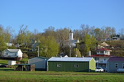
Derby, Indiana
Appearance
Derby, Indiana | |
|---|---|
 Overview from Mulzer Park | |
| Coordinates: 38°1′49″N 86°31′38″W / 38.03028°N 86.52722°W | |
| Country | United States |
| State | Indiana |
| County | Perry |
| Township | Union |
| Elevation | 453 ft (138 m) |
| Time zone | UTC-6 (Central (CST)) |
| • Summer (DST) | UTC-5 (CDT) |
| ZIP code | 47525 |
| Area code(s) | 812, 930 |
| GNIS feature ID | 450842[1] |
Derby is an unincorporated community along the Ohio River in far southern Union Township, Perry County, in the U.S. state of Indiana.[1] It lies at the intersection of State Roads 66 and 70 above the city of Tell City, the county seat of Perry County.[2] Although Derby is unincorporated, it has a post office, with the ZIP code of 47525.[3]
History
[edit]
Derby was platted in 1835.[4] The community was named after Derby, in Ireland.[5] A post office has been in operation at Derby since 1852.[6]
Education
[edit]Union Township is in Perry Central Community School Corporation.[7]
Previously the community had its own high school. The school colors were black and gold, and the mascot was the warriors. This school consolidated into Perry Central High School.[8]
See also
[edit]References
[edit]- ^ a b c U.S. Geological Survey Geographic Names Information System: Derby, Indiana
- ^ DeLorme. Indiana Atlas & Gazetteer, 3rd ed., Yarmouth: DeLorme, 2004, p. 62-63. ISBN 0-89933-319-2.
- ^ Zip Code Lookup
- ^ Hunt, Thomas James De la (1916). Perry County: A History. W.K. Stewart. p. 82.
- ^ Baker, Ronald L. (October 1995). From Needmore to Prosperity: Hoosier Place Names in Folklore and History. Indiana University Press. p. 113. ISBN 978-0-253-32866-3.
...for Derby, Ireland, the home of his ancestors.
- ^ "Perry County". Jim Forte Postal History. Retrieved October 2, 2015.
- ^ "2020 CENSUS - SCHOOL DISTRICT REFERENCE MAP: Perry County, IN" (PDF). U.S. Census Bureau. Retrieved June 12, 2024. - Text list
- ^ Blackford, Nathan (July 15, 2014). "School's Out Forever". Evansville Living. Evansville, Indiana. Retrieved June 12, 2024.


