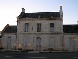
Asnières-la-Giraud
Asnières-la-Giraud | |
|---|---|
 Town hall | |
| Coordinates: 45°53′N 0°31′W / 45.89°N 0.52°W | |
| Country | France |
| Region | Nouvelle-Aquitaine |
| Department | Charente-Maritime |
| Arrondissement | Saint-Jean-d'Angély |
| Canton | Matha |
| Intercommunality | CC Vals Saintonge |
| Government | |
| • Mayor (2020–2026) | Christian Ferru[1] |
| Area 1 | 18.64 km2 (7.20 sq mi) |
| Population (2021)[2] | 977 |
| • Density | 52/km2 (140/sq mi) |
| Time zone | UTC+01:00 (CET) |
| • Summer (DST) | UTC+02:00 (CEST) |
| INSEE/Postal code | 17022 /17400 |
| Elevation | 22–82 m (72–269 ft) (avg. 49 m or 161 ft) |
| 1 French Land Register data, which excludes lakes, ponds, glaciers > 1 km2 (0.386 sq mi or 247 acres) and river estuaries. | |
Asnières-la-Giraud (French pronunciation: [ɑnjɛʁ la ʒiʁo]) is a commune in the Charente-Maritime department in the Nouvelle-Aquitaine region of south-western France.
Geography
[edit]Asnières-la-Giraud is located some 38 km east of Rochefort and 7 km south of Saint-Jean-d'Angély. Access to the commune is by the D150 road from Saint-Jean-d'Angély in the north which passes through the west of the commune and the village and continues to Saint-Hilaire-de-Villefranche. The D120 road from Saint-Jean-d'Angély passes through the east of the commune and continues to Sainte-Même. The D217 road connects the D120 and the D150 in the commune and continues west to Mazeray. Apart from the village there are the hamlets of La Touzetterie on the north-eastern border, Moulin de la Laigne, La Laigne, Le Plonget, La Giraud, La Rue d'Asnières, Le Puits d'Asnières, Champmiaud, and La Tranche in the south. There are some patches of forest but most of the commune is farmland.[3]
The Loubat river flows south through the commune west of the D150 and through the village before continuing south.[3]
Geologically it is a limestone plateau of the Tithonian period (formerly called Portlandian)
Neighbouring communes and villages
[edit]Administration
[edit]List of Successive Mayors[4]
| From | To | Name | Party | Position |
|---|---|---|---|---|
| 2001 | 2014 | Guy Madé | Retired | |
| 2014 | 2026 | Christian Ferru |
Budget and Taxation
[edit]The Taxation rates are: 6.28% for housing tax, 11.80% for developed land, 37% for undeveloped land, and 8% business tax. As the community of communes also levies all four taxes: respectively 2.46%, 5.50%, 11.91%, and 3.82%, this gives a total, before the department and the region, of: 8.74% for housing tax, 17.30% for developed land, 48.91% for undeveloped land, and 11.82% business tax (2007 figures).
Demography
[edit]The inhabitants of the commune are known as Asnierois or Asnieroises in French.[5]
|
| ||||||||||||||||||||||||||||||||||||||||||||||||||||||||||||||||||||||||||||||||||||||||||||||||||||||||||||||||||
| Source: EHESS[6] and INSEE[7] | |||||||||||||||||||||||||||||||||||||||||||||||||||||||||||||||||||||||||||||||||||||||||||||||||||||||||||||||||||
Distribution of Age Groups
[edit]The population of the town is younger than the departmental average.
Percentage Distribution of Age Groups in Asnières-la-Giraud and Charente-Maritime Department in 2017
| Asnières-la-Giraud | Charente-Maritime | |||
|---|---|---|---|---|
| Age Range | Men | Women | Men | Women |
| 0 to 14 Years | 15.8 | 19.7 | 16.3 | 14.3 |
| 15 to 29 Years | 15.3 | 13.5 | 15.4 | 13.1 |
| 30 to 44 Years | 19.0 | 19.6 | 16.7 | 16.1 |
| 45 to 59 Years | 23.1 | 21.7 | 20.2 | 19.9 |
| 60 to 74 Years | 20.2 | 16.3 | 21.1 | 22.0 |
| 75 to 89 Years | 6.5 | 8.4 | 9.4 | 12.3 |
| 90 Years+ | 0.2 | 0.7 | 1.0 | 2.4 |
Economy
[edit]Asnières-la-Giraud has always been an agricultural and viticultural; commune. Nevertheless, there are many trades in the commune: a garage, a mechanically construction business, an Emmaus warehouse, and activities linked to tourism with a hotel, a rural cottage, and a Youth Hostel called Chantageasse. The vineyards are in the Appellation d'origine contrôlée (AOC) region of Cognac: the Fins Bois cru.
Culture and heritage
[edit]
Civil heritage
[edit]- The Fontaines d'Asnières milk factory
 [9] at 17 Rue de la Laiterie is registered as a historical monument.
 - An old well

Religious heritage
[edit]- The Church of Saint Medard
Notable people linked to the commune
[edit]- Auguste Roy de Loulay, French politician born on 26 August 1818 at Asnières-la-Giraud.
See also
[edit]References
[edit]- ^ "Répertoire national des élus: les maires". data.gouv.fr, Plateforme ouverte des données publiques françaises (in French). 2 December 2020.
- ^ "Populations légales 2021" (in French). The National Institute of Statistics and Economic Studies. 28 December 2023.
- ^ a b c Google Maps
- ^ List of Mayors of France (in French)
- ^ Le nom des habitants du 17 - Charente-Maritime, habitants.fr
- ^ Des villages de Cassini aux communes d'aujourd'hui: Commune data sheet Asnières-la-Giraud, EHESS (in French).
- ^ a b Évolution et structure de la population en 2017: Commune d'Asnières-la-Giraud (17022)
- ^ Évolution et structure de la population en 2017: Département de la Charente-Maritime (17)
- ^ Ministry of Culture, Mérimée IA17000323 Fontaines d'Asnières milk factory (in French)
External links
[edit]- Asnières-la-Giraud on Géoportail, National Geographic Institute (IGN) website (in French)
- Annieres on the 1750 Cassini Map


