Fluvio Amazon
Apparentia
Iste articulo concerne le fluvio. Pro le feminas guerrier, vide Amazon. Pro altere usos, vide Amazonas (disambiguation).
| Fluvio Amazon |
|---|
| Instantia de: fluvio |
 
|

|
| Coordinatas: 4°26'54.10"S, 73°27'21.24"W, 0°42'28"N, 50°5'22"W |
| Affluentes: Madeira River[*], Tapajós River[*], Xingu River[*], Rio Negro[*], Japurá River[*], Napo River[*], Putumayo River[*], Preto da Eva River[*], Nanay River[*], Javary River[*], Paru River[*], Trombetas River[*], Jari River[*], Jutai River[*], Urubu River[*], Jandiatuba River[*], Manacapuru River[*], Uatumã River[*], Nhamundá River[*], Arabela River[*], Guajará River[*], Ucayali River[*], Paraná Urariá[*], Ampiyacu River[*], Apayacu River[*], Atacuari River[*], Itaya River[*], Juruá River[*], Marañón River[*] |
| Continente: America del Sud |
| Paises: Peru, Colombia, Brasil |
| ID VIAF: [316430069] |
| ID GeoNames: [3407729] |
| Commons: Amazon River |

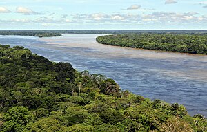
Le Fluvio Amazon in America del Sud es le secunde plus longe fluvio in le mundo e le plus grande per fluxo de aqua, con un medie discarga plus grande que le sequente septe plus grande fluvios combinate (non includente le Madeira o le Rio Negro, que es affluentes del Amazon). Le Fluvio Amazon, que ha le plus grande bassino hydrographic in le mundo, circa 7.050.000 kilometros quadrate, da conto de approximativemente un quinto del fluxo total del fluvios del mundo. [1] [2]
Vide etiam
[modificar | modificar fonte]Referentias
[modificar | modificar fonte]- ↑ Tom Sterling: Der Amazonas. Time-Life Bücher 1979, 8th German Printing, p. 19
- ↑ Smith, Nigel J.H. (2002). Amazon Sweet Sea: Land, Life, and Water at the River's Mouth. University of Texas Press, 1–2. ISBN 9780292777705.


