Utilisateur:FMtrl/Brouillon
Apparence
Gallery
[modifier | modifier le code]- A gallery of major river basins with tributaries
-
The basin of the Amazon River is a system made up of many tributary streams. The streams shown on the map besides the Amazon are tributaries of the Amazon.
-
The Benue River is fed by multiple tributaries originating in the Adamawa Plateau; many of the highest tributaries are seasonal streams. The Benue is itself a major tributary of the Niger.
-
Huai River (itself a tributary of the Yangtze) and tributaries
-
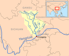
Jialing River (itself a tributary of the Yangtze) and tributaries
-
The Liao River is a much simpler example of a river basin with tributaries. The main tributaries noted on this map are the Hun River, Taizi River, Dongliao River, Xinkai River, Xiliao River, Xar Moron River and the Laoha River. The Xiliao River's tributaries are the Xar Moron and Laoha rivers.
-
The Mekong is a trans-boundary river, originating in the Tibetan Plateau. Its upper tributary river systems (e.g. the Salween River) are restricted to narrow gorges, but the tributaries that feed its lower reaches (e.g. the Mun River) cover larger areas.
-
The water basin of the Wabash River; the other rivers (not including the Ohio River) are tributaries of the Wabash River. The Vermillion River (and its forks) is a highlighted example of a tributary of the Wabash River. The Wabash River is also a tributary of the Ohio River, which in turn is a tributary of the Mississippi River.
-
The Yamuna is the second-largest tributary river of the Ganges and the longest tributary in India. It flows almost parallel to the Ganges about its right bank for 1 376 kilomètres ( Unité « » inconnue du modèle {{Conversion}}.) before merging with it at the Triveni Sangam, Allahabad.


