Peest
Peest | |
|---|---|
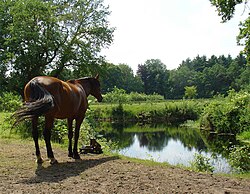
 Westerveen near Peest | |
Location in province of Drenthe in the Netherlands | |
| Coordinates: 53°3′37″N 6°29′57″E / 53.06028°N 6.49917°E | |
| Country | Netherlands |
| Province | Drenthe |
| Municipality | Noordenveld |
| Area | |
| • Total | 4.94 km2 (1.91 sq mi) |
| Elevation | 10 m (30 ft) |
| Population (2021)[1] | |
| • Total | 145 |
| • Density | 29/km2 (76/sq mi) |
| Time zone | UTC+1 (CET) |
| • Summer (DST) | UTC+2 (CEST) |
| Postal code | 9334[1] |
| Dialing code | 0592 |
Peest is a village in the Netherlands and it is part of the Noordenveld municipality in Drenthe. The Airport Norg used to be located near the village.
History
[edit]Peest is an esdorp which developed around the heath.[3] It was first mentioned around 1300 as "apud Peest". The etymology of the name is unclear.[4] The farms which were constructed prior to 1850 are parallel to the communal pasture while the later farms are at right angles.[5] In 1840, the village had 80 inhabitants.[3]
The hunebed (dolmen) D5 is located of the road to Zeijen.[3]
Airport Norg
[edit]In the summer of 1940, the German authorities started to construct Fliegerhorst Norg near Peest. 2,500 workers were brought in to build an airport with three runways on a 280 hectares (690 acres) terrain. The airport suffered from serious drainage problems and was hardly ever used.[6] A large pond was made in the centre to solve the drainage problem, but to no avail. The road around the pond was named Hitlerring.[7]
Even though the airport had operational problems, it was mined in April 1945 by French paratroopers. After the war, the airport was used a dump site for ammunition. Between 1999 and 2011, there was de-fusion operation to remove the 200,000 pieces of ammunition from the site.[6]
The airport seemingly resembles a swastika from the air, however that is a visual illusion. The Germans even painted to roads in order to obscure the airport from view.[7]
Gallery
[edit]-
Farm in Peest
-
Pumping station for the airstrip
-
House in Peest
-
Fuel storage at Airport Norg
References
[edit]- ^ a b c "Kerncijfers wijken en buurten 2021". Central Bureau of Statistics. Retrieved 10 March 2022.
Two entries
- ^ "Postcodetool for 9334TA". Actueel Hoogtebestand Nederland (in Dutch). Het Waterschapshuis. Retrieved 10 March 2022.
- ^ a b c "Peest". Plaatsengids (in Dutch). Retrieved 10 March 2022.
- ^ "Peest". Etymologiebank (in Dutch). Retrieved 10 March 2022.
- ^ "Peest". Geheugen van Drenthe (in Dutch). Retrieved 10 March 2022.
- ^ a b "Vliegveld Peest geen succes". Drenthe in de oorlog (in Dutch). Retrieved 10 March 2022.
- ^ a b "Wat is de Hitlerring bij Peest". 75 jaar vrijheid (in Dutch). Retrieved 10 March 2022.


