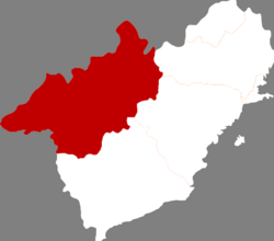
Jianchang County
Jianchang
建昌县 Chienchang | |
|---|---|
 Location in Huludao City | |
| Coordinates: 40°49′N 119°50′E / 40.817°N 119.833°E | |
| Country | People's Republic of China |
| Province | Liaoning |
| Prefecture-level city | Huludao |
| County seat | Jianchang Town (建昌镇) |
| Area | |
| • Total | 3,195 km2 (1,234 sq mi) |
| Elevation | 369 m (1,211 ft) |
| Population | |
| • Total | 600,000 |
| • Density | 190/km2 (490/sq mi) |
| Time zone | UTC+8 (China Standard) |
| Postal code | 125300 |
Jianchang (Chinese: 建昌; pinyin: Jiànchāng) is a county of Huludao City in the southwest of Liaoning province, China. It is the largest division of Huludao, with an area of 3,195 square kilometres (1,234 sq mi),[1] and population of 600,000[when?], located in mountainous terrain 85 kilometres (53 mi) west of that city, serviced by China National Highway 306. The Weizhangzi–Tashan railway also passes through the County.[2]
Near the border with Hebei province lies the Jianchang Longtan Grand Canyon, home to wide variety of plants and animals. In 2009 a Troodontid dinosaur fossil with feathers was discovered in Jianchang. It is the earliest known such fossil and provides evidence for the link between dinosaurs and birds.[3] Also found here, in Jiufotang Formation rocks, was the early modern bird Schizooura.[4]
Administrative divisions
[edit]There are seven towns, 21 townships, and one ethnic township in the county.[5]
Towns:
- Jianchang (建昌镇)
- Bajiazi (八家子镇)
- Lamadong (喇嘛洞镇)
- Yaowangmiao (药王庙镇)
- Tangshenmiao (汤神庙镇)
- Linglongta (玲珑塔镇)
- Datun (大屯镇)
Townships:
|
|
|
Climate
[edit]| Climate data for Jianchang, elevation 367 m (1,204 ft), (1991–2020 normals, extremes 1981–2010) | |||||||||||||
|---|---|---|---|---|---|---|---|---|---|---|---|---|---|
| Month | Jan | Feb | Mar | Apr | May | Jun | Jul | Aug | Sep | Oct | Nov | Dec | Year |
| Record high °C (°F) | 12.6 (54.7) |
19.1 (66.4) |
28.5 (83.3) |
32.3 (90.1) |
38.2 (100.8) |
38.4 (101.1) |
40.7 (105.3) |
37.3 (99.1) |
34.9 (94.8) |
31.1 (88.0) |
21.4 (70.5) |
18.3 (64.9) |
40.7 (105.3) |
| Mean daily maximum °C (°F) | −1.4 (29.5) |
2.7 (36.9) |
9.6 (49.3) |
17.9 (64.2) |
24.5 (76.1) |
27.8 (82.0) |
29.1 (84.4) |
28.4 (83.1) |
24.5 (76.1) |
17.1 (62.8) |
7.2 (45.0) |
0.2 (32.4) |
15.6 (60.2) |
| Daily mean °C (°F) | −8.6 (16.5) |
−4.5 (23.9) |
2.8 (37.0) |
11.4 (52.5) |
18.0 (64.4) |
21.7 (71.1) |
23.9 (75.0) |
22.7 (72.9) |
17.5 (63.5) |
9.9 (49.8) |
0.7 (33.3) |
−6.4 (20.5) |
9.1 (48.4) |
| Mean daily minimum °C (°F) | −14.0 (6.8) |
−10.3 (13.5) |
−3.3 (26.1) |
4.8 (40.6) |
11.4 (52.5) |
16.1 (61.0) |
19.3 (66.7) |
17.9 (64.2) |
11.5 (52.7) |
3.8 (38.8) |
−4.4 (24.1) |
−11.4 (11.5) |
3.5 (38.2) |
| Record low °C (°F) | −28.3 (−18.9) |
−24.3 (−11.7) |
−19.7 (−3.5) |
−6.9 (19.6) |
1.5 (34.7) |
6.7 (44.1) |
11.8 (53.2) |
7.5 (45.5) |
−0.2 (31.6) |
−8.2 (17.2) |
−19.5 (−3.1) |
−24.9 (−12.8) |
−28.3 (−18.9) |
| Average precipitation mm (inches) | 1.9 (0.07) |
2.7 (0.11) |
6.4 (0.25) |
24.0 (0.94) |
47.9 (1.89) |
100.8 (3.97) |
160.3 (6.31) |
122.5 (4.82) |
44.7 (1.76) |
25.9 (1.02) |
10.4 (0.41) |
1.6 (0.06) |
549.1 (21.61) |
| Average precipitation days (≥ 0.1 mm) | 1.6 | 1.5 | 2.8 | 5.0 | 7.4 | 11.7 | 12.0 | 9.1 | 6.7 | 4.8 | 2.9 | 1.6 | 67.1 |
| Average snowy days | 2.6 | 2.1 | 2.9 | 1.3 | 0.1 | 0 | 0 | 0 | 0 | 0.6 | 3.1 | 2.7 | 15.4 |
| Average relative humidity (%) | 48 | 43 | 39 | 41 | 47 | 64 | 76 | 76 | 68 | 57 | 53 | 51 | 55 |
| Mean monthly sunshine hours | 196.1 | 195.2 | 234.3 | 244.0 | 266.7 | 231.7 | 213.0 | 229.4 | 233.7 | 223.9 | 185.4 | 184.2 | 2,637.6 |
| Percent possible sunshine | 66 | 64 | 63 | 61 | 59 | 52 | 47 | 54 | 63 | 66 | 63 | 64 | 60 |
| Source: China Meteorological Administration[6][7] | |||||||||||||
References
[edit]- ^ "Huludao Administrative Districts". Huludao Municipal Government. Archived from the original on 2009-10-05. Retrieved 2010-01-08.
- ^ "建昌县" [Jianchang County]. hldnews.com (in Chinese). Retrieved 9 March 2021.
- ^ China's new dinosaur fossil sheds light on bird origin, 2009/09/25
- ^ Shuang Zhou, Zhong-He Zhou and Jingmai K. O’Connor (2012). "A new basal beaked ornithurine bird from the Lower Cretaceous of Western Liaoning, China" (PDF). Vertebrata PalAsiatica. 50 (1): 9–24.
- ^ 2011年统计用区划代码和城乡划分代码:建昌县 (in Chinese). National Bureau of Statistics of the People's Republic of China. Archived from the original on November 28, 2012. Retrieved 2012-07-17.
- ^ 中国气象数据网 – WeatherBk Data (in Simplified Chinese). China Meteorological Administration. Retrieved 29 July 2023.
- ^ 中国气象数据网 (in Simplified Chinese). China Meteorological Administration. Retrieved 29 July 2023.

