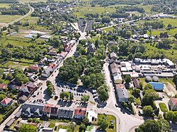
Dobre, Masovian Voivodeship
Dobre | |
|---|---|
Town | |
 Aerial view of Dobre | |
| Coordinates: 52°19′17″N 21°40′42″E / 52.32139°N 21.67833°E | |
| Country | |
| Voivodeship | Masovian |
| County | Mińsk |
| Gmina | Dobre |
| Town rights | 1530 |
| Population | |
| • Total | 1,627 |
| Time zone | UTC+1 (CET) |
| • Summer (DST) | UTC+2 (CEST) |
| Vehicle registration | WM |
Dobre [ˈdɔbrɛ] is a town in Mińsk County, Masovian Voivodeship, in east-central Poland. It is the seat of the gmina (administrative district) called Gmina Dobre.[1] It lies approximately 18 kilometres (11 mi) north-east of Mińsk Mazowiecki and 48 km (30 mi) east of Warsaw.
History
[edit]
Dobre was the ancestral seat of the Dobrzyniecki noble family.[2] Jan Dobrzyniecki, podstoli of Zakroczym, obtained town rights for Dobre from King Sigismund I the Old.[2] It was a private town of the Dobrzyniecki, and later also Massalski and Szydłowski families, administratively located in the Liw Land in the Masovian Voivodeship in the Greater Poland Province of the Kingdom of Poland.[2]
Following the joint German-Soviet invasion of Poland, which started World War II in September 1939, Dobre was occupied by Germany until 1944.
References
[edit]- ^ "Central Statistical Office (GUS) - TERYT (National Register of Territorial Land Apportionment Journal)" (in Polish). 2008-06-01.
- ^ a b c Słownik geograficzny Królestwa Polskiego i innych krajów słowiańskich, Tom II (in Polish). Warszawa. 1881. p. 69.
{{cite book}}: CS1 maint: location missing publisher (link)


