
Charnay, Rhône
Charnay | |
|---|---|
 The church in Charnay | |
 Coat of arms | |
Location of Charnay  | |
 Charnay  Charnay | |
| Coordinates: 45°53′29″N 4°40′09″E / 45.8914°N 4.6692°E | |
| Country | France |
| Region | Auvergne-Rhône-Alpes |
| Department | Rhône |
| Arrondissement | Villefranche-sur-Saône |
| Canton | Val d'Oingt |
| Intercommunality | Beaujolais Pierres Dorées |
| Government | |
| • Mayor (2020–2026) | Laurent Dubuy[1] |
Area 1 | 7.06 km2 (2.73 sq mi) |
| Population (2022)[2] | 1,031 |
| • Density | 150/km2 (380/sq mi) |
| Time zone | UTC+01:00 (CET) |
| • Summer (DST) | UTC+02:00 (CEST) |
| INSEE/Postal code | 69047 /69380 |
| Elevation | 206–446 m (676–1,463 ft) (avg. 450 m or 1,480 ft) |
| 1 French Land Register data, which excludes lakes, ponds, glaciers > 1 km2 (0.386 sq mi or 247 acres) and river estuaries. | |
Charnay (French pronunciation: [ʃaʁnɛ]) is a commune in the Rhône department in eastern France.
The village is part of the Beaujolais wine region and is home to numerous wineries. It is also regionally famous for its authentic medieval village.
Demography
[edit]| Year | Pop. | ±% p.a. |
|---|---|---|
| 1968 | 515 | — |
| 1975 | 551 | +0.97% |
| 1982 | 609 | +1.44% |
| 1990 | 775 | +3.06% |
| 1999 | 964 | +2.45% |
| 2009 | 1,078 | +1.12% |
| 2014 | 1,072 | −0.11% |
| 2020 | 1,047 | −0.39% |
| Source: INSEE[3] | ||
Gallery
[edit]-
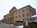
 The church
 -
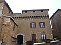
 The medieval castle, built in golden colored stones
 -
 The medieval castle, now Charnay's city hall
 -
 The medieval village
 -
 The medieval village
 -
 The medieval village
 -
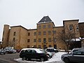
 The Mansarde castle (16th century)


See also
[edit]Communes of the Rhône department
References
[edit]- ^ "Répertoire national des élus: les maires". data.gouv.fr, Plateforme ouverte des données publiques françaises (in French). 2 December 2020.
- ^ "Populations de référence 2022" (in French). The National Institute of Statistics and Economic Studies. 19 December 2024.
- ^ Population en historique depuis 1968, INSEE
Wikimedia Commons has media related to Charnay (Rhône).
| Authority control databases: National |
|---|
This Rhône geographical article is a stub. You can help Wikipedia by expanding it. |