İlkadım
İlkadım | |
|---|---|
District and municipality | |
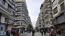
 İstiklal Street in İlkadım | |
 Map showing İlkadım District in Samsun Province | |
| Coordinates: 41°17′N 36°20′E / 41.283°N 36.333°E | |
| Country | Turkey |
| Province | Samsun |
| Government | |
| • Mayor | Ihsan Kurnaz (AKP) |
| Area | 155 km2 (60 sq mi) |
| Population (2022)[1] | 333,518 |
| • Density | 2,200/km2 (5,600/sq mi) |
| Time zone | UTC+3 (TRT) |
| Area code | 0362 |
| Climate | Cfa |
| Website | www |
Ilkadim is a municipality and district of Samsun Province, Turkey.[2] Its area is 155 km2,[3] and its population is 333,518 (2022).[1] It is located on the coast of Black Sea. The district has an altitude of 5 meters.[4][need quotation to verify]It is also the most populous district of Black Sea Region. The majority of the urbanized portion of Samsun City is located within İlkadım.
İlkadım is bordered by Canik district to the east, the Black Sea in the north, Atakum district to the west, and Kavak district to the south.
Geography
[edit]İlkadım is within the city of Samsun. The district includes the port of Samsun. The name İlkadım refers to Atatürk's arrival in Samsun via sea in the ship the Bandirma in order to start the Turkish War of Independence on 19 May 1919. (İlkadım means first step).
History
[edit]
Excavations have been carried out on the höyük of Dündartepe revealed a settlement of Chalcolithic age. During the early Hellenistic age there was a colony named Amisos (in Greek Αμισός) founded by the colonialists from Miletus. The colony was captured by Julius Caesar of Roman Empire in 43 BC. After 1071, the city was captured by Danishmends [citation needed] and Seljuks[citation needed]. In 1413 was incorporated into Ottoman Empire by Mehmet I.[5]
İlkadım is a part of the Samsun Metropolitan Municipality. In 1994 it was declared a municipality within the city borders of the Samsun Metropolitan Municipality. With a law in 2008, it became one of the 4 central districts of Samsun by including the lower level municipalities of Gazi and Yeşilkent.[6][7] At the 2013 Turkish local government reorganisation, the rural part of the district was integrated into the municipality, the villages becoming neighbourhoods.[8]
Currently, it is the largest and most developed district of Samsun and the Black Sea Region in terms of population. With the growth of the region, commercial activities in the center have declined and much of the middle class of Samsun has moved to newer and more modern neighborhoods. Efforts have been made to revitalize İlkadım like the construction of the Sheraton Hotel Samsun, Piazza Samsun and the reconstruction of Samsun Saathane Square and Republic Square (Samsun). The district is also served by extensive public transit including the Samsun Tram.

The district was named İlkadım because Atatürk came to Samsun and took the first step towards independence here on May 19, 1919.
Population
[edit]In 2008, İlkadım had a population of 303,202, that figure grew to 333,518 by 2022.[9] Despite continued population growth, the figure has been shadowed by the growth of neighboring districts like Atakum. The ten most populous neighborhoods in the district are respectively; Fevzi Çakmak, Kışla, Kazım Karabekir, Derebahçe, Adalet, Bahçelievler, Kadıköy, Karasamsun, Kadifekale and Ilyasköy. These ten neighborhoods with a total population of 144,387 (2022) make up 43% of the district's population.[1] In 2022, İlkadım constituted 24% of the population of Samsun Province.[1]
| Year | Pop. | ±% p.a. |
|---|---|---|
| 2008 | 303,202 | — |
| 2012 | 312,332 | +0.74% |
| 2017 | 333,218 | +1.30% |
| 2022 | 333,518 | +0.02% |
| Source: TÜIK (2008-2022)[9] | ||
Composition
[edit]There are 61 neighbourhoods in İlkadım District:[10]
- 19 Mayıs
- Adalet
- Ahulu
- Akgöl
- Anadolu
- Aşağıavdan
- Ataköy
- Avdan
- Bahçelievler
- Baruthane
- Bilmece
- Çanakçı
- Çandır
- Çatalarmut
- Çay
- Cedit
- Çelikalan
- Çiftlik
- Çivril
- Derebahçe
- Derecik
- Fatih
- Fevziçakmak
- Gürgendağ
- Güzeldere
- Hançerli
- Hastane
- Hürriyet
- İlyasköy
- İstasyon
- Kadamut
- Kadifekale
- Kadıköy
- Kale
- Kalkanca
- Kapaklı
- Karadeniz
- Karasamsun
- Kavacık
- Kazımkarabekir
- Kılıçdede
- Kıran
- Kışla
- Kökçüoğlu
- Kuşçulu
- Liman
- Pazar
- Rasathane
- Reşadiye
- Saitbey
- Selahiye
- Tepecik
- Toybelen
- Ulugazi
- Unkapanı
- Uzgur
- Yaşardoğu
- Yenidoğan
- Yeşiltepe
- Zafer
- Zeytinlik
Government and politics
[edit]This section needs to be updated. (April 2024) |
The mayor is Necattin Demirtaş (Good Party). The Mayor of the Samsun Metropolitan Municipality is Mustafa Demir and the Governor of Samsun Province is Zülkif Dağlı. İlkadım is a traditionally politically conservative district.
See also
[edit]- Surgical Instruments and Health Museum
- Statue of Honor, the landmark of Samsun
- Samsun Saathane Square, Samsun's Historic Square
- Samsun Clock Tower, Samsun's Clock Tower
- Piazza Samsun, the largest mall in the Central Black Sea Region
References
[edit]- ^ a b c d "Address-based population registration system (ADNKS) results dated 31 December 2022, Favorite Reports" (XLS). TÜİK. Retrieved 12 July 2023.
- ^ Büyükşehir İlçe Belediyesi, Turkey Civil Administration Departments Inventory. Retrieved 12 July 2023.
- ^ "İl ve İlçe Yüz ölçümleri". General Directorate of Mapping. Retrieved 12 July 2023.
- ^ "Coğrafi Yapı". Archived from the original on 22 February 2014. Retrieved 6 February 2014.
- ^ "İlkadım Belediyesi". www.ilkadim.bel.tr.
- ^ Kanun No. 5747, Resmî Gazete, 22 March 2008.
- ^ "İl İdaresi ve Mülki Bölümler Şube Müdürlüğü İstatistikleri - İl ve İlçe Kuruluş Tarihleri" (PDF) (in Turkish). p. 72. Retrieved 4 September 2023.
- ^ "Law No. 6360". Official Gazette (in Turkish). 6 December 2012.
- ^ a b "Population Of SRE-1, SRE-2, Provinces and Districts". TÜIK. Retrieved 4 September 2023.
- ^ Mahalle, Turkey Civil Administration Departments Inventory. Retrieved 12 July 2023.


