
Sebastopol, New South Wales
| Sebastopol New South Wales | |
|---|---|
 Entering Sebastopol | |
 Sebastopol | |
| Coordinates | 34°34′48″S 147°31′03″E / 34.58000°S 147.51750°E |
| Population | 56 (SAL 2021)[1] |
| Postcode(s) | 2666 |
| Elevation | 299 m (981 ft) |
| Location |
|
| LGA(s) | Temora Shire |
| County | Clarendon |
| State electorate(s) | Cootamundra |
| Federal division(s) | Riverina |
Sebastopol is a village community in the north east part of the Riverina, in New South Wales, Australia. It is situated about 15 kilometres south of Temora and 19 kilometres north of Junee Reefs. The name is also applied to the surrounding rural locality, for statistical and postal purposes.
The area now known as Sebastopol lies on the traditional lands of Wiradjuri people.[2]
It was named after Sevastopol, the site of an important battle during the Crimean War. Gold was mined there from c. 1870.[3] It was the first to be discovered of a line of gold mining locations that ran north-north-west, from Junee Reefs, through Sebastopol, Temora, Reefton, and Barmedman, to West Wyalong.[4]
The first large quartz reef mine on the field was the Morning Star, begun in 1869, which was also one of the most productive. The other large mine was the Homeward Bound. Both of these mines were rich in gold at a relatively shallow depth, yielding around eight ounces of gold to the ton; more gold was recovered by retreating the tailings from these mines.[4] Gold mining continued in the area into the first half of the 20th Century.[5][6]
The early days of the gold field were difficult; the closest police were at Morangorell, and water, carried from springs near Combaning, had to be purchased by the cask.[4]
The mines were long-lived enough for a mining village of around 500 people to form. It had three hotels, three stores and two butcher's shops.[4] Sebastopol Post Office opened on 7 March 1870 and closed in 1973.[7] Sebastopol had a school from 1871 to 1949.[8] An Anglican church building remains in the locality some distance away from the old mining village; it is no longer used as a church, having been sold in 2016.[9] Apart from some ruined buildings, little remains of the original mining village.
Near Sebastopol is the 248 hectare site of a 90 Mega-Watt solar farm that became operational in December 2021.[10][11]
-
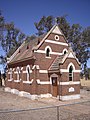 St Stephen's Church Sebastopol
 -
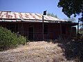 Ruins at Sebastopol


Notes and references
[edit]- ^ Australian Bureau of Statistics (28 June 2022). "Sebastopol (NSW) (suburb and locality)". Australian Census 2021 QuickStats. Retrieved 28 June 2022.
- ^ Studies, Australian Institute of Aboriginal and Torres Strait Islander (26 November 2024). "Map of Indigenous Australia". aiatsis.gov.au. Retrieved 15 February 2025.
- ^ "Sebastopol Reefs". Sydney Mail (NSW : 1860 - 1871). 30 April 1870. p. 9. Retrieved 5 March 2021.
- ^ a b c d Webster, Rob (1951). The First Fifty Years of Temora. Temora, NSW: Temora Heritage Committee. pp. 35, 36.
- ^ "GOLD AT SEBASTOPOL". Daily Advertiser (Wagga Wagga). 7 July 1931. p. 2. Retrieved 15 February 2025.
- ^ "MILD GOLD RUSH FOLLOWS SEBASTOPOL STRIKE". Daily Advertiser (Wagga Wagga). 21 February 1947. p. 1. Retrieved 15 February 2025.
- ^ Premier Postal History, Post Office List, retrieved 11 June 2009
- ^ "Sebastopol". nswgovschoolhistory.cese.nsw.gov.au. Retrieved 5 March 2021.
- ^ Design, UBC Web. "St Stephen's Anglican Church - Former | Churches Australia". www.churchesaustralia.org. Retrieved 15 February 2025.
- ^ "Home". FRV Sebastopol Solar Farm. Retrieved 4 December 2022.
- ^ "NSW's Sebastopol Solar Farm up and running". pv magazine Australia. Retrieved 4 December 2022.