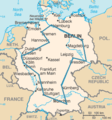
Fayl:TSP Deutschland 3.png
TSP_Deutschland_3.png (326 × 350 piksel, fayl hajmi: 15 KB, MIME tipi: image/png)
Fayl tarixi
Faylning biror paytdagi holatini koʻrish uchun tegishli sana/vaqtga bosingiz.
| Sana/Vaqt | Miniatura | Oʻlchamlari | Foydalanuvchi | Izoh | |
|---|---|---|---|---|---|
| joriy | 14:36, 2021-yil 1-yanvar |  | 326 × 350 (15 KB) | Ras67 | frame removed |
| 03:50, 2008-yil 28-dekabr |  | 328 �� 352 (15 KB) | Amirki | {{Information |Description={{de|Kürzester Rundreiseweg durch die 15 größten Städte Deutschlands. Insgesamt sind 14!/2 = 43 589 145 600 verschiedene Wege möglich.}} |Source={{PD-user-w|de|wikipedia|MrMonstar}} |Date= |Author={{PD-user-w|de|wikipedia|M |
Fayllarga ishoratlar
Bu faylga quyidagi sahifa bogʻlangan:
Faylning global foydalanilishi
Ushbu fayl quyidagi vikilarda ishlatilyapti:
- ar.wikipedia.org loyihasida foydalanilishi
- bg.wikipedia.org loyihasida foydalanilishi
- bs.wikipedia.org loyihasida foydalanilishi
- ca.wikipedia.org loyihasida foydalanilishi
- cs.wikipedia.org loyihasida foydalanilishi
- de.wikipedia.org loyihasida foydalanilishi
- de.wikiversity.org loyihasida foydalanilishi
- de.wiktionary.org loyihasida foydalanilishi
- el.wikipedia.org loyihasida foydalanilishi
- en.wikipedia.org loyihasida foydalanilishi
- es.wikipedia.org loyihasida foydalanilishi
- eu.wikipedia.org loyihasida foydalanilishi
- fr.wikipedia.org loyihasida foydalanilishi
- gl.wikipedia.org loyihasida foydalanilishi
- he.wikipedia.org loyihasida foydalanilishi
- hu.wikipedia.org loyihasida foydalanilishi
- id.wikipedia.org loyihasida foydalanilishi
- it.wikipedia.org loyihasida foydalanilishi
- lt.wikipedia.org loyihasida foydalanilishi
- mwl.wikipedia.org loyihasida foydalanilishi
- nl.wikipedia.org loyihasida foydalanilishi
- nl.wiktionary.org loyihasida foydalanilishi
- pl.wikipedia.org loyihasida foydalanilishi
- pl.wiktionary.org loyihasida foydalanilishi
- pt.wikipedia.org loyihasida foydalanilishi
Ushbu faylni koʻproq global foydalanishdan koʻring.


