Valea Chioarului
Appearance
Valea Chioarului | |
|---|---|
 Wooden church in Vărai | |
 Location in Maramureș County | |
| Coordinates: 47°26′N 23°29′E / 47.433°N 23.483°E | |
| Country | Romania |
| County | Maramureș |
| Government | |
| • Mayor (2020–2024) | Ioan Sorin Burde (PSD) |
| Area | 79.08 km2 (30.53 sq mi) |
| Elevation | 299 m (981 ft) |
| Population (2021-12-01)[1] | 2,002 |
| • Density | 25/km2 (66/sq mi) |
| Time zone | EET/EEST (UTC+2/+3) |
| Postal code | 437370 |
| Area code | +40 x59 |
| Vehicle reg. | MM |
| Website | www |

Valea Chioarului (Hungarian: Kővárgara) is a commune in Maramureș County, Romania. It is composed of six villages: Curtuiușu Mare (Nagykörtvélyes), Durușa (Durusa), Fericea (Szamosfericse), Mesteacăn (Kisnyíres), Valea Chioarului, and Vărai (Kőváralja).
The commune is located in the southwestern part of Maramureș County, 34 km (21 mi) from the county seat, Baia Mare, on the border with Sălaj County. It lies at an altitude of about 300 m (980 ft), on the banks of the river Bârsău.
Valea Chioarului is crossed by national road DN1C (part of European route E58), which runs from Cluj-Napoca north towards Baia Mare and the Ukrainian border at Halmeu.
See also
[edit]References
[edit]-
Wooden church in Valea Chioarului
-
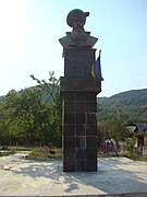
Bust of Michael the Brave in Valea Chioarului
Wikimedia Commons has media related to Valea Chioarului, Maramureș.


