Orroli
Orroli
Arrolli | |
|---|---|
| Comune di Orroli | |
 Nuraghe Arrubiu | |
| Coordinates: 39°42′N 9°15′E / 39.700°N 9.250°E | |
| Country | Italy |
| Region | Sardinia |
| Province | South Sardinia |
| Area | |
| • Total | 75.6 km2 (29.2 sq mi) |
| Elevation | 550 m (1,800 ft) |
| Population (Dec. 2004)[1] | |
| • Total | 2,647 |
| • Density | 35/km2 (91/sq mi) |
| Demonym | Orrolesi |
| Time zone | UTC+1 (CET) |
| • Summer (DST) | UTC+2 (CEST) |
| Postal code | 08030 |
| Dialing code | 0782 |
| Website | Official website |
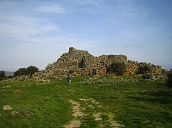
Orroli, meaning "downy oak" (Arrólli in Sardinian language) is, a comune (municipality) in the Province of South Sardinia in the Italian region of Sardinia, located about 67.4 kilometres (41.9 mi) north of Cagliari. As of 31 December 2010, it had a population of 2,430 and an area of 75.6 square kilometres (29.2 sq mi).[2] Orroli territory hosts one of the most important nuraghi of Sardinia called Nuraghe Arrubiu, the only intact example of a five-tower nuraghe, one of the dam in the Flumendosa river and the dam of the Mulargia, which gave name to the artificial lake. Within the village there are many hostels and bed and breakfasts organized around old lifestyles and ancient traditions.
Orroli borders the following municipalities: Escalaplano, Esterzili, Goni, Nurri, Siurgus Donigala.
Demographic evolution
[edit]
References
[edit]- ^ "Popolazione Residente al 1° Gennaio 2018". Italian National Institute of Statistics. Retrieved 16 March 2019.
- ^ All demographics and other statistics: Italian statistical institute Istat.
External links
[edit]


