Manikpur, Chitrakoot
Appearance
(Redirected from Manikpur Sarhat)
Manikpur
Manikpur | |
|---|---|
Town | |
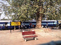
 Manikpur Junction railway station | |
| Coordinates: 25°04′N 81°06′E / 25.067°N 81.100°E | |
| Country | |
| State | Uttar Pradesh |
| District | Chitrakoot |
| Government | |
| • Type | NAGAR PANCHAYAT |
| Population (2011) | |
| • Total | 16,467 |
| Languages~ Hindi.bandhi.bundelkhandi | |
| • Official | Hindi |
| Time zone | UTC+5:30 (IST) |
| Vehicle registration | UP 96 |
| Website | up |
Manikpur is a town in the Indian state of Uttar Pradesh in Chitrakoot district, it is a nagar panchayat, and Tehsil in District. It is an important junction on the Jabalpur-Prayagraj railway line.
Geography
[edit]Manikpur is located on 25°04′N 81°06′E / 25.067°N 81.100°E. [1] It is surrounded by the large Vindhya mountain range.
Demographics
[edit]As of the 2011 India census,[2] Manikpur Sarhat had a population of 15,435. Males constitute 53% of the population and females 47%. Manikpur Sarhat has an average literacy rate of 62%, higher than the national average of 59.5%: male literacy is 72%, and female literacy is 50%. In Manikpur Sarhat, 18% of the population is under 6 years of age.
Transportation
[edit]- It is an important railway Station on Jabalpur-Prayagraj Section. One other railway line goes to Jhansi. Many important trains halt in Manikpur.[3]
- Manikpur is connected to Chitrakoot and Rajpur by State Highway, and by private bus services to all nearest major cities.
References
[edit]- ^ "Maps, Weather, and Airports for Manikpur, India".
- ^ "Census of India 2001: Data from the 2001 Census, including cities, villages and towns (Provisional)". Census Commission of India. Archived from the original on 16 June 2004. Retrieved 1 November 2008.
- ^ "144 Departures from Manikpur NCR/North Central Zone - Railway Enquiry".


