Gölbaşı, Ankara
Gölbaşı | |
|---|---|
District and municipality | |
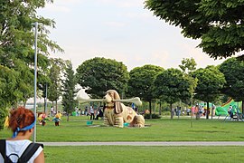
 Lake Mogan Park | |
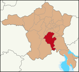
 Map showing Gölbaşı District in Ankara Province | |
| Coordinates: 39°47′43″N 32°48′10″E / 39.79528°N 32.80278°E | |
| Country | Turkey |
| Province | Ankara |
| Government | |
| • Mayor | Yakup Odabaşı (CHP) |
Area | 1,364 km2 (527 sq mi) |
| Elevation | 970 m (3,180 ft) |
| Population (2022)[1] | 150,047 |
| • Density | 110/km2 (280/sq mi) |
| Time zone | UTC+3 (TRT) |
| Area code | 0312 |
| Website | www |

Gölbaşı is a municipality and district of Ankara Province, Turkey.[2] Its area is 1,364 km2,[3] and its population is 150,047 (2022).[1] It is 20 km (12 mi) south of the city of Ankara. Its elevation is 970 m (3,182 ft). The district includes the Mogan and Eymir lakes.

Although the lakes are polluted and infested with mosquitoes, the picnic areas and lakeside restaurants of Gölbaşı serve as a popular retreat from the city for the people of Ankara. A number of government departments have accommodations here, and the town is slowly but surely joining up with the city as the green space between the two disappears. Türk Telekom have their satellite ground control in the area.
History
[edit]Archaeological research in the area has revealed since 3000 BC a succession of civilısations including Hittites, Phrygians, Greeks ,Romans, and Byzantines. Excavated sites include Selametli, Tuluntaş, Tuluntaş-Ortaçayır, Kızılcaşar-Gökçepınar, Karagedik, Bacılar, Bezirhane Kültepe, Bezirhane-Kepenekçi and İncek-Harmantepe.
The area has long been occupied by Turks, and it was here that Timur hid his elephants in the woods before the Battle of Ankara.
Places of interest
[edit]- Tulumtaş caves - 15 km (9 mi) from Ankara, 5 km (3 mi) of limestone cave with stalagmites and stalactites
- Gölbaşı Ground Station, satellite telecommunication center of Türksat,
- Turkish Satellite Assembly, Integration and Test Center (Turkish: Uydu Montaj, Entegrasyon ve Test Merkezi) operated by the Turkish Aerospace Industries (TAI),
- Gölbaşı International Billiards Complex with the seay of the Turkish Billiards Federation.
Demographics
[edit]| Year | Pop. | ±% p.a. |
|---|---|---|
| 1985 | 31,671 | — |
| 2000 | 62,602 | +4.65% |
| 2007 | 73,670 | +2.35% |
| 2012 | 110,643 | +8.47% |
| 2017 | 130,363 | +3.33% |
| 2022 | 150,047 | +2.85% |
| Source: TÜIK (2007–2022)[1] | ||
The population of Gölbaşı city is growing very fast. The main reasons are: a high natural growth rate, migration from rural areas (rural exodus) and immigration from the city of Ankara.
Composition
[edit]There are 54 neighbourhoods in Gölbaşı District:[5]
- Ahiboz
- Akörençarşak
- Altunçanak
- Bağiçi
- Bahçelievler
- Ballıkpınar
- Bezirhane
- Boyalık
- Çayırlı
- Çeltek
- Çimşit
- Dikilitaş
- Emirler
- Eymir
- Gaziosmanpaşa
- Gökçehüyük
- Gölbek
- Günalan
- Hacıhasan
- Hacılar
- Hacımuratlı
- Halaçlı
- İkizce
- İncek
- Karaali Merkez
- Karaali Yazlık
- Karacaören
- Karagedik Aydın
- Karagedik Ercan
- Karaoğlan
- Karşıyaka
- Kırıklı
- Kızılcaşar
- Koparan
- Mahmatlı
- Mahmatlıbahçe
- Oğulbey
- Örencik
- Oyaca Akarsu
- Oyaca Yeşilçam
- Şafak
- Seğmenler
- Selametli Şehit Emrah
- Soğulcak
- Subaşı
- Taşpınar
- Tepeyurt
- Topaklı
- Tulumtaş
- Velihimmetli
- Yağlıpınar
- Yavrucuk
- Yaylabağ
- Yurtbeyi
References
[edit]- ^ a b c "Population Of SRE-1, SRE-2, Provinces and Districts". TÜIK. Retrieved 20 June 2023.
- ^ Büyükşehir İlçe Belediyesi, Turkey Civil Administration Departments Inventory. Retrieved 8 June 2023.
- ^ "İl ve İlçe Yüz ölçümleri". General Directorate of Mapping. Retrieved 22 May 2023.
- ^ Turkish Statistical Institute
- ^ Mahalle, Turkey Civil Administration Departments Inventory. Retrieved 22 May 2023.
External links
[edit]- District governor's official website (in Turkish)
- District municipality's official website (in Turkish)


