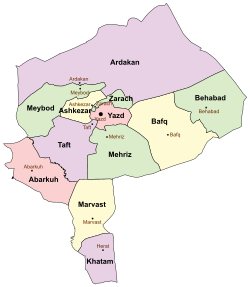
Abarkuh County
Appearance
Abarkuh County
Persian: شهرستان ابرکوه | |
|---|---|
 Jameh Mosque of Abarkuh | |
 Location of Abarkuh County in Yazd province (left, pink) | |
 Location of Yazd province in Iran | |
| Coordinates: 31°06′N 53°24′E / 31.100°N 53.400°E[1] | |
| Country | |
| Province | Yazd |
| Capital | Abarkuh |
| Districts | Central, Bahman |
| Population (2016)[2] | |
| • Total | 51,552 |
| Time zone | UTC+3:30 (IRST) |
| Abarkuh County can be found at GEOnet Names Server, at this link, by opening the Advanced Search box, entering "9207372" in the "Unique Feature Id" form, and clicking on "Search Database". | |
Abarkuh County (Persian: شهرستان ابرکوه) is in Yazd province, Iran. Its capital is the city of Abarkuh.[3]
Demographics
[edit]Population
[edit]At the time of the 2006 National Census, the county's population was 42,610 in 11,660 households.[4] The following census in 2011 counted 46,662 people in 13,640 households.[5] The 2016 census measured the population of the county as 51,552 in 16,026 households.[2]
Administrative divisions
[edit]Abarkuh County's population history and administrative structure over three consecutive censuses are shown in the following table.
| Administrative Divisions | 2006[4] | 2011[5] | 2016[2] |
|---|---|---|---|
| Central District | 29,609 | 33,217 | 36,907 |
| Faragheh RD | 3,102 | 3,439 | 3,456 |
| Tirjerd RD | 5,513 | 5,792 | 5,927 |
| Abarkuh (city) | 20,994 | 23,986 | 27,524 |
| Bahman District | 13,001 | 13,429 | 14,196 |
| Esfandar RD | 3,824 | 3,992 | 4,044 |
| Mehrabad RD | 1,976 | 2,047 | 2,055 |
| Mehrdasht (city)[a] | 7,201 | 7,390 | 8,097 |
| Total | 42,610 | 46,662 | 51,552 |
| RD = Rural District | |||
See also
[edit]![]() Media related to Abarkuh County at Wikimedia Commons
Media related to Abarkuh County at Wikimedia Commons
Notes
[edit]References
[edit]- ^ OpenStreetMap contributors (12 November 2024). "Abarkuh County" (Map). OpenStreetMap (in Persian). Retrieved 12 November 2024.
- ^ a b c Census of the Islamic Republic of Iran, 1395 (2016): Yazd Province. amar.org.ir (Report) (in Persian). The Statistical Center of Iran. Archived from the original (Excel) on 18 November 2020. Retrieved 19 December 2022.
- ^ Habibi, Hassan (c. 2023) [Approved 18 October 1373]. Creation and establishment of three districts and one county under the citizenship of Yazd province. lamtakam.com (Report) (in Persian). Ministry of the Interior, Council of Ministers. Proposal 1.4.42.3034; Letter 93808-907; Notification 10667/T109K. Archived from the original on 20 December 2023. Retrieved 20 December 2023 – via Lam ta Kam.
- ^ a b Census of the Islamic Republic of Iran, 1385 (2006): Yazd Province. amar.org.ir (Report) (in Persian). The Statistical Center of Iran. Archived from the original (Excel) on 20 September 2011. Retrieved 25 September 2022.
- ^ a b Census of the Islamic Republic of Iran, 1390 (2011): Yazd Province. irandataportal.syr.edu (Report) (in Persian). The Statistical Center of Iran. Archived from the original (Excel) on 20 January 2023. Retrieved 19 December 2022 – via Iran Data Portal, Syracuse University.
- ^ Habibi, Hassan (c. 2023) [Approved 25 January 1378]. Merger of Mehrabad village in Yazd province with Nusratabad and Ardi villages, and they are known as Mehrdasht city. lamtakam.com (Report) (in Persian). Ministry of the Interior, Council of Ministers. Proposal 1.4.42.2277; Notification 47165/T19885AH. Archived from the original on 20 December 2023. Retrieved 20 December 2023 – via Lam ta Kam.

