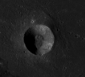
Sulpicius Gallus is a small, bowl-shaped lunar impact crater that lies near the southwestern edge of the Mare Serenitatis. The crater is named after the 2nd century BC Roman astronomer Gaius Sulpicius Gallus.[1]
 LRO image | |
| Coordinates | 19°38′N 11°41′E / 19.63°N 11.68°E |
|---|---|
| Diameter | 12 km |
| Depth | 2.2 km |
| Colongitude | 349° at sunrise |
| Eponym | Gaius Sulpicius Gallus |

About 10 kilometers to the south and east is the Montes Haemus range that forms the edge of the Serenitatis basin. This crater has a relatively high albedo, with a sharp-edged rim that displays little appearance of wear. There is a small rise at the midpoint. Recent deposits of highland material have been observed within the crater interior. This material was observed to be orange by Apollo 17 astronauts during their LMP ascent.[2]

To the northwest is a rille system designated the Rimae Sulpicius Gallus. These extend to the northwest for a distance of about 90 kilometers, curving and branching out to follow the edge of the mare.
Satellite craters
editBy convention these features are identified on lunar maps by placing the letter on the side of the crater midpoint that is closest to Sulpicius Gallus.
| Sulpicius Gallus |
Latitude | Longitude | Diameter |
|---|---|---|---|
| A | 22.1° N | 8.9° E | 4 km |
| B | 18.0° N | 13.0° E | 7 km |
| G | 19.8° N | 6.3° E | 6 km |
| H | 20.6° N | 5.7° E | 5 km |
| M | 20.4° N | 8.7° E | 5 km |
-
Sulpicius Gallus A
References
edit- ^ "Gazetteer of Planetary Nomenclature | Sulpicius Gallus". usgs.gov. International Astronomical Union. Retrieved August 23, 2017.
- ^ "Apollo 17 - Technical air-to-ground voice transcriptions" (PDF). nasa.gov. December 1972. Retrieved September 13, 2022.
- Andersson, L. E.; Whitaker, E. A. (1982). NASA Catalogue of Lunar Nomenclature. NASA RP-1097.
- Bussey, B.; Spudis, P. (2004). The Clementine Atlas of the Moon. New York: Cambridge University Press. ISBN 978-0-521-81528-4.
- Cocks, Elijah E.; Cocks, Josiah C. (1995). Who's Who on the Moon: A Biographical Dictionary of Lunar Nomenclature. Tudor Publishers. ISBN 978-0-936389-27-1.
- McDowell, Jonathan (July 15, 2007). "Lunar Nomenclature". Jonathan's Space Report. Retrieved 2007-10-24.
- Menzel, D. H.; Minnaert, M.; Levin, B.; Dollfus, A.; Bell, B. (1971). "Report on Lunar Nomenclature by the Working Group of Commission 17 of the IAU". Space Science Reviews. 12 (2): 136–186. Bibcode:1971SSRv...12..136M. doi:10.1007/BF00171763. S2CID 122125855.
- Moore, Patrick (2001). On the Moon. Sterling Publishing Co. ISBN 978-0-304-35469-6.
- Price, Fred W. (1988). The Moon Observer's Handbook. Cambridge University Press. ISBN 978-0-521-33500-3.
- Rükl, Antonín (1990). Atlas of the Moon. Kalmbach Books. ISBN 978-0-913135-17-4.
- Webb, Rev. T. W. (1962). Celestial Objects for Common Telescopes (6th revised ed.). Dover. ISBN 978-0-486-20917-3.
- Whitaker, Ewen A. (1999). Mapping and Naming the Moon. Cambridge University Press. ISBN 978-0-521-62248-6.
- Wlasuk, Peter T. (2000). Observing the Moon. Springer. ISBN 978-1-85233-193-1.
Further reading
edit- "SMART-1 view of crater Sulpicius Gallus". European Space Agency. 2006-07-12. Retrieved 2006-07-18.
- J.F. Bell III; B. R. Hawke (1995). "Compositional variability of the Serenitatis/Tranquillitatis region of the Moon from telescopic Multispectral Imaging and Spectroscopy". Icarus. 118 (1): 51–68. Bibcode:1995Icar..118...51B. doi:10.1006/icar.1995.1177.
External links
edit- Sulpicius Gallus at The Moon Wiki
- Rimae Sulpicius Gallus at The Moon Wiki
- LTO-42D4 Sulpicius Gallus — L&PI topographic map
- Wood, Chuck (February 11, 2006). "Draped Landscapes". Lunar Photo of the Day. Archived from the original on June 14, 2011. - the rille
- Wood, Chuck (December 26, 2008). "Lunar Education". Lunar Photo of the Day. - both the crater and the rille
- Wood, Chuck (July 23, 2010). "Curves Near the Shore". Lunar Photo of the Day. - the rille