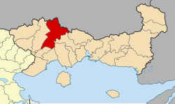
Paranesti (Greek: Παρανέστι, romanized: Paranésti) is a municipality in the Rhodope Mountains of northeastern Drama regional unit, Greece. It consists of two municipal units: Paranesti and Nikoforos. The largest villages of the municipal unit Paranesti are Paranésti (the municipal seat, pop. 625), Mesochório (105), Káto Thólos (123), Χágnanto (43), and Prasináda (32).
Paranesti
Παρανέστι | |
|---|---|
 | |
| Coordinates: 41°16′N 24°30′E / 41.267°N 24.500°E | |
| Country | Greece |
| Administrative region | East Macedonia and Thrace |
| Regional unit | Drama |
| Area | |
| • Municipality | 1,029.4 km2 (397.5 sq mi) |
| • Municipal unit | 788.4 km2 (304.4 sq mi) |
| Population (2021)[1] | |
| • Municipality | 2,843 |
| • Density | 2.8/km2 (7.2/sq mi) |
| • Municipal unit | 994 |
| • Municipal unit density | 1.3/km2 (3.3/sq mi) |
| • Community | 824 |
| Time zone | UTC+2 (EET) |
| • Summer (DST) | UTC+3 (EEST) |
| Vehicle registration | ΡΜ |
The Natural History Museum of Paranesti is located in Paranesti.
Municipality
editThe municipality Paranesti was formed at the 2011 local government reform by the merger of the following 2 former municipalities, that became municipal units (constituent communities in brackets):[2]
- Nikiforos (Adriani, Ano Pyxari, Nikiforos, Platania, Platanovrysi, Ptelea, Ypsili Rachi)
- Paranesti (Paranesti, Sili, Tholos)
The municipality has an area of 1029.392 km2, the municipal unit 788.394 km2.[3]
References
edit- ^ "Αποτελέσματα Απογραφής Πληθυσμού - Κατοικιών 2021, Μόνιμος Πληθυσμός κατά οικισμό" [Results of the 2021 Population - Housing Census, Permanent population by settlement] (in Greek). Hellenic Statistical Authority. 29 March 2024.
- ^ "ΦΕΚ B 1292/2010, Kallikratis reform municipalities" (in Greek). Government Gazette.
- ^ "Population & housing census 2001 (incl. area and average elevation)" (PDF) (in Greek). National Statistical Service of Greece.
External links
edit- Official website (in Greek)

