This article needs additional citations for verification. (January 2018) |
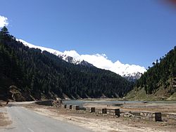
Naran (Hindko, Urdu: ناران, romanized: Nārān, IPA: [nɑːɾɑːn]) is a town and popular tourist destination in the upper Kaghan Valley in the Mansehra District of the Khyber Pakhtunkhwa province of Pakistan. It is located 119 kilometers (74 mi) from Mansehra city at an altitude of 2,409 meters (7,904 ft). It is located about 65 kilometers (40 mi) away from Babusar Top.[1] It is one of the most popular tourist attractions locally as well as internationally.[2] Naran Valley is also Pakistan's most visited Valley, around 1.5 million people visit Naran Valley every year.
Naran
ناران | |
|---|---|
 Naran Town | |
| Coordinates: 34°54′22″N 73°38′58″E / 34.90611°N 73.64944°E | |
| Country | |
| Province | |
| District | Mansehra |
| Elevation | 2,409 m (7,904 ft) |
| Time zone | UTC+5 (PST) |
| Highways | |
Tourism In Naran
editNaran Kaghan is famous as a tourist destination, owing to its pleasant weather during peak season. Every year thousands of tourists rush to explore the valley. It is also the gateway to Gilgit Hunza in Summers by Babusar Pass. Naran Bazaar is very crowded in the summers with hotels and restaurants offering their services. In 2020, the government expects that 5 million tourists will explore the valley.[citation needed]
Climate
editNaran has a humid continental climate (Koppen Climate Classification Dfb),[3] but the weatherbox below suggests a subarctic (Dfc) climate. There is significant rainfall in summers and heavy snowfall in winters. The region is Alpine in geography and climate, with forests and meadows dominating the landscape. The weather usually remains cloudy throughout the year. During the winters the temperature often remains below 0 °C with heavy snowfall. In the summers the temperature rarely exceeds 15 °C with heavy rainfall. Naran remains busy in summer, starting earlier, and tourism is extending up to late in the fall. The average annual temperature in Naran is 4.7 °C.
| Climate data for Naran, Kaghan Valley | |||||||||||||
|---|---|---|---|---|---|---|---|---|---|---|---|---|---|
| Month | Jan | Feb | Mar | Apr | May | Jun | Jul | Aug | Sep | Oct | Nov | Dec | Year |
| Record high °C (°F) | 6.3 (43.3) |
11.3 (52.3) |
15.3 (59.5) |
21 (70) |
22.1 (71.8) |
25.3 (77.5) |
24.5 (76.1) |
24.1 (75.4) |
19.3 (66.7) |
17.4 (63.3) |
13.2 (55.8) |
8.8 (47.8) |
25.3 (77.5) |
| Mean daily maximum °C (°F) | −3.4 (25.9) |
3.4 (38.1) |
8.5 (47.3) |
11.3 (52.3) |
15.2 (59.4) |
17.4 (63.3) |
18.1 (64.6) |
16.5 (61.7) |
14.8 (58.6) |
10.6 (51.1) |
5.2 (41.4) |
1.2 (34.2) |
9.9 (49.8) |
| Daily mean °C (°F) | −7.4 (18.7) |
−2.5 (27.5) |
2.2 (36.0) |
5.0 (41.0) |
9.7 (49.5) |
12.6 (54.7) |
13.9 (57.0) |
11.6 (52.9) |
9.0 (48.2) |
4.6 (40.3) |
0.4 (32.7) |
−3.0 (26.6) |
4.7 (40.4) |
| Mean daily minimum °C (°F) | −11.4 (11.5) |
−8.4 (16.9) |
−4.1 (24.6) |
−1.3 (29.7) |
4.3 (39.7) |
7.8 (46.0) |
9.7 (49.5) |
6.8 (44.2) |
3.3 (37.9) |
−1.3 (29.7) |
−4.4 (24.1) |
−7.2 (19.0) |
−0.5 (31.1) |
| Record low °C (°F) | −23.9 (−11.0) |
−14.3 (6.3) |
−15.4 (4.3) |
−8.4 (16.9) |
−8.7 (16.3) |
−0.5 (31.1) |
−1.3 (29.7) |
−2.0 (28.4) |
−6.3 (20.7) |
−9.4 (15.1) |
−14.3 (6.3) |
−18.1 (−0.6) |
−23.9 (−11.0) |
| Average precipitation mm (inches) | 59 (2.3) |
72 (2.8) |
94 (3.7) |
101 (4.0) |
79 (3.1) |
48 (1.9) |
102 (4.0) |
107 (4.2) |
56 (2.2) |
37 (1.5) |
18 (0.7) |
30 (1.2) |
803 (31.6) |
| Average rainy days | 5 | 9 | 10 | 10 | 10 | 8 | 8 | 8 | 5 | 5 | 3 | 5 | 86 |
| Average snowy days | 14 | 7 | 6 | 7 | 5 | 0 | 2 | 3 | 0 | 4 | 7 | 13 | 68 |
| Source 1: Climate-Data.org (altitude: 2409m)[3] | |||||||||||||
| Source 2: My Weather 2[4] | |||||||||||||
See also
edit- Saiful Muluk Lake
- Lulusar Lake
- Dudipatsar Lake
- Pyala Lake
References
edit- ^ "Naran on map". Google Maps. Retrieved 13 September 2019.
- ^ "Top 10 Breathtaking views & Must See Places in Naran Kaghan". narankaghan.pk. 2018-05-29. Retrieved 2019-08-09.
- ^ a b "Temperature, Climate graph, Climate table for Naran". Climate-Data.org. Retrieved 2017-08-30.
- ^ "Weather". Retrieved 30 August 2017.

