File:Malacca Sultanate de.svg
From Wikimedia Commons, the free media repository
Jump to navigation
Jump to search

Size of this PNG preview of this SVG file: 512 × 581 pixels. Other resolutions: 211 × 240 pixels | 423 × 480 pixels | 677 × 768 pixels | 902 × 1,024 pixels | 1,805 × 2,048 pixels.
Original file (SVG file, nominally 512 × 581 pixels, file size: 367 KB)
File information
Structured data
Captions
Captions
Add a one-line explanation of what this file represents
Summary
[edit]| DescriptionMalacca Sultanate de.svg |
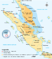
Deutsch: Ausdehnung des Sultanats von Malakka (1402–1511) über die Malaiische Halbinsel und die Ostküste Sumatras. Quelle: "Atlas Sejarah Indonesia dan Dunia" (Der Atlas zur Geschichte Indonesiens und der Welt), PT Pembina Peraga Jakarta 1996.
Bahasa Indonesia: Peta sejarah Kesultanan Malaka (1402–1511) Wilayahnya mencakup Semenanjung Malaya, Pesisir Timur Sumatera dan pulau-pulau sekitarnya Dibuat dan disempurnakan berdasarkan "Atlas Sejarah Indonesia dan Dunia", PT Pembina Peraga Jakarta 1996.
English: The historical map of Malacca Sultanate (1402–1511) Malay Peninsula and East Coast of Sumatra. Made and improved based on "Atlas Sejarah Indonesia dan Dunia" (The Atlas of Indonesian and World History), PT Pembina Peraga Jakarta 1996. |
||
| Date | |||
| Source |
This file was derived from: Malacca Sultanate en.svg |
||
| Author | Gunawan Kartapranata, German translation and adaption by Furfur | ||
| Permission (Reusing this file) |
I, the copyright holder of this work, hereby publish it under the following licenses:
This file is licensed under the Creative Commons Attribution-Share Alike 4.0 International license.
You may select the license of your choice. |
||
| Other versions |
[edit]
|
||
| SVG development InfoField | This map was created with a text editor. |
File history
Click on a date/time to view the file as it appeared at that time.
| Date/Time | Thumbnail | Dimensions | User | Comment | |
|---|---|---|---|---|---|
| current | 20:28, 13 December 2018 |  | 512 × 581 (367 KB) | Furfur (talk | contribs) | Kosmetik |
| 20:20, 13 December 2018 |  | 512 × 581 (367 KB) | Furfur (talk | contribs) | == {{int:filedesc}} == {{Information |Description={{User:Medium69/Traduction}} {{de|1=Ausdehnung des Sultanats von Malakka (1402–1511) über die Malaiische Halbinsel und die Ostküste Sumatras. Quelle: "Atlas Sejarah Indonesia dan Dunia" (Der Atlas zur Geschichte Indonesiens und der Welt), PT Pembina Peraga Jakarta 1996.}} {{id|1=Peta sejarah Kesultanan Malaka (1402–1511) Wilayahnya mencakup Semenanjung Malaya, Pesisir Timur Sumatera dan pulau-pulau sekitarnya Dibuat dan disempurnakan berdasark... |
You cannot overwrite this file.
File usage on Commons
The following 5 pages use this file:
File usage on other wikis
The following other wikis use this file:
- Usage on de.wikipedia.org
Metadata
This file contains additional information such as Exif metadata which may have been added by the digital camera, scanner, or software program used to create or digitize it. If the file has been modified from its original state, some details such as the timestamp may not fully reflect those of the original file. The timestamp is only as accurate as the clock in the camera, and it may be completely wrong.
| Width | 100% |
|---|---|
| Height | 100% |


