From Wikimedia Commons, the free media repository
The introductions of the country, dependency and region entries are in the native languages and in English. The other introductions are in English.
| |
|

|
Inner Mongolia
|
 Flag of the People's Republic of China |
|
|
|
|
|
内蒙古

|
|
|
|
| 中文
|
内蒙古 - 内蒙古自治区[1]
内蒙古自治区,简称内蒙古,是中華人民共和国北部边疆的一个自治区。首府是呼和浩特。
|
| Монгол[2]
|
Өвөр Монголын - Өвөр Монголын Өөртөө Засах Орон[3]
БНХАУ-ын хойд хэсэгт орших Монгол угсаатны автономит эрх бүхий улс. Нийслэл нь Хөх хот. 1947 онд Хятадын коммунист намын нөлөөн дор Улаанхүү нар Өвөр Монголын өөртөө засах орныг байгуулсан. Монгол угсаатны газар нутаг боловч эдүгээ хүн амын 80 илүү хувь нь нангиад үндэстэн эзэлж буй.
|
| English
|
Inner Mongolia - Inner Mongolia Autonomous Region
Inner Mongolia Autonomous Region is a Mongol autonomous region of the People's Republic of ► China. Inner Mongolia borders, from east to west, the provinces of Heilongjiang, Jilin, Liaoning, Hebei, Shanxi, Shaanxi, ► Ningxia Hui Autonomous Region, and Gansu, while to the north it borders Mongolia and Russia. It has an area of 1.18 million km² occupying 12% of China's land area, about the same as France and Spain added together, or Texas and California added together. It has a population of 23,84 million as of 2004. The capital is Hohhot.
|
|
| Short name
|
Inner Mongolia
|
| Official name
|
Inner Mongolia Autonomous Region
|
| Status
|
Autonomous region of the People's Republic of ► China
|
| Capital
|
呼和浩特[4] (Hohhot)
Хөх хот[5]
|
| Population
|
24,706,291 inhabitants
|
| Area
|
1,183,000 km²
|
| Major languages
|
Chinese, Mongolian
|
| Major religions
|
Chinese folk religion, Buddhism
|
| More information
|
Inner Mongolia, Geography of Inner Mongolia, History of Inner Mongolia and Politics of Inner Mongolia
|
| More images
|
Inner Mongolia - Inner Mongolia (Category).
|
|
General maps

|
Location
|
Notes and references
General remarks:
- The WIKIMEDIA COMMONS Atlas of the World is an organized and commented collection of geographical, political and historical maps available at Wikimedia Commons. The main page is therefore the portal to maps and cartography on Wikimedia. That page contains links to entries by country, continent and by topic as well as general notes and references.
- Every entry has an introduction section in English. If other languages are native and/or official in an entity, introductions in other languages are added in separate sections. The text of the introduction(s) is based on the content of the Wikipedia encyclopedia. For sources of the introduction see therefore the Wikipedia entries linked to. The same goes for the texts in the history sections.
- Historical maps are included in the continent, country and dependency entries.
- The status of various entities is disputed. See the content for the entities concerned.
- The maps of former countries that are more or less continued by a present-day country or had a territory included in only one or two countries are included in the atlas of the present-day country. For example the Ottoman Empire can be found in the Atlas of Turkey.
- ↑ Romanization according to the Hanyu Pinyin standard: Nèi Měnggǔ - Nèi Měnggǔ Zìzhìqū.
- ↑ Inner Mongolia uses the traditional alphabet, not the Cyrillic alphabet
- ↑ Romanization: Öbür Monggol-un - Öbür Monggol-un Öbertegen Jasahu Oron.
- ↑ Romanization according to the Hanyu Pinyin standard: Hūhéhàotè.
- ↑ Romanization: Khekh Khot.
|
Entries available in the atlas
- General pages
- World
- Continents and oceans
- Themes
- Historical eras
- States with wide recognition
- States with limited recognition
- Dependencies and other overseas territories
- Country subdivisions
- Belgium
- China (mainland)
- India
- Pakistan
- Spain
- United Kingdom
- United States
- Russia
- Other
- Disputed subnational territories
- Other regions
- Cities
- Former sovereign states
- Former dependencies and overseas territories
- Former disputed territories
|


 Huhhot (呼和浩特) City, the Capital of Inner Mogolia
 Baotou (包头) City
 Bayan Nur League (巴彦淖尔盟)
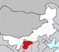 Ortos (鄂尔多斯) City
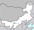 Wuhai (乌海) City
 Alxa League (阿拉善盟)
 Ulan Qabu League (乌兰察布盟)
 Xilin Gol League (锡林郭勒盟)
 Chifeng (赤峰) City
 Tongliao (通辽) City
 Xing'an League (兴安盟)
 Hulun Buir League (呼伦贝尔盟)


