The introductions of the country, dependency and region entries are in the native languages and in English. The other introductions are in English.
| |
|
Atlas-country

|
Togo
|
|
|
|
|
|
|
|
Togo
|
|
|
|
| Français
|
Togo - République Togolaise
La République Togolaise' est un pays d’Afrique de l'Ouest ayant des frontières communes avec le Bénin à l’est, le Burkina Faso au nord, et le Ghana à l’ouest. Sa façade sud est ouverte sur le golfe du Bénin. La population est estimée en 2006 à environ 5,4 millions d’habitants pour une densité de 95 hab/km².
|
| English
|
Togo - Togolese Republic
The Togolese Republic is a country in West Africa bordering ► Ghana in the west, ► Benin in the east and ► Burkina Faso in the north. In the south, it has a short Gulf of Guinea coast, on which the capital Lomé is located.
|
|
|
|
| Short name
|
Togo
|
| Official name
|
Togolese Republic
|
| Status
|
Independent country since 1960
|
| Location
|
West Africa
|
| Capital
|
Lomé
|
| Population
|
7,706,000 inhabitants
|
| Area
|
56,785 square kilometres (21,925 sq mi)
|
| Major languages
|
French (official), Ewe, Gen, Kabye and Dagomba
|
| Major religions
|
Indigenous beliefs, Christianity, Islam
|
| More information
|
Togo, Geography of Togo, History of Togo and Politics of Togo
|
| More images
|
Togo - Togo (Category).
|
|
General maps

|
Carte du Togo
Map of Togo
|

|
Carte Satellite
Satellite map
|

|
Carte politique du Togo (en allemand)
Political map of Togo (in German)
|
Maps of divisions
This section holds maps of the administrative divisions.
History maps
This section holds a short summary of the history of the area of present-day Togo, illustrated with maps, including historical maps of former countries and empires that included present-day Togo.

|
Division du Togo en 1918
Division of Togo in 1918
|
Old maps
This section holds copies of original general maps more than 70 years old.

|
Togoland en 1885
|

|
Togoland en 1920
|
Other maps
Notes and references
General remarks:
- The WIKIMEDIA COMMONS Atlas of the World is an organized and commented collection of geographical, political and historical maps available at Wikimedia Commons. The main page is therefore the portal to maps and cartography on Wikimedia. That page contains links to entries by country, continent and by topic as well as general notes and references.
- Every entry has an introduction section in English. If other languages are native and/or official in an entity, introductions in other languages are added in separate sections. The text of the introduction(s) is based on the content of the Wikipedia encyclopedia. For sources of the introduction see therefore the Wikipedia entries linked to. The same goes for the texts in the history sections.
- Historical maps are included in the continent, country and dependency entries.
- The status of various entities is disputed. See the content for the entities concerned.
- The maps of former countries that are more or less continued by a present-day country or had a territory included in only one or two countries are included in the atlas of the present-day country. For example the Ottoman Empire can be found in the Atlas of Turkey.
|
Entries available in the atlas
- General pages
- World
- Continents and oceans
- Themes
- Historical eras
- States with wide recognition
- States with limited recognition
- Dependencies and other overseas territories
- Country subdivisions
- Belgium
- China (mainland)
- India
- Pakistan
- Spain
- United Kingdom
- United States
- Russia
- Other
- Disputed subnational territories
- Other regions
- Cities
- Former sovereign states
- Former dependencies and overseas territories
- Former disputed territories
|


 Savannes region
 Political map of Togo, Savannes marked (in German)
 Prefectures of Savannes

 Kara region
 Political map of Togo, Kara marked (in German)
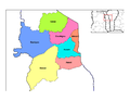 Prefectures of Kara

 Centrale region
 Political map of Togo, Centrale marked (in German)
 Prefectures of Centrale

 Plateaux region
 Political map of Togo, Plateaux marked (in German)
 Prefectures of Plateaux

 Maritime region
 Political map of Togo, Maritime marked (in German)
 Prefectures of Maritime


