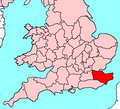
Slika:KentBrit5.PNG
Videz
KentBrit5.PNG (625 × 569 točk, velikost datoteke: 26 KB, MIME-vrsta: image/png)
Zgodovina datoteke
Kliknite datum in čas za ogled datoteke, ki je bila takrat naložena.
| Datum in čas | Sličica | Velikost | Uporabnik | Komentar | |
|---|---|---|---|---|---|
| trenutno | 18:04, 10. maj 2009 |  | 625 × 569 (26 KB) | Hogweard | {{Information |Description= |Source= |Date= |Author= |Permission= |other_versions= }} |
| 20:05, 3. april 2009 |  | 625 × 569 (26 KB) | Hogweard | {{Information |Description= |Source= |Date= |Author= |Permission= |other_versions= }} | |
| 23:58, 13. november 2008 |  | 625 × 569 (18 KB) | Hogweard | {{Information |Description=Kent |Source=Own work |Date=12 November 2008 |Author=User:Hogweard |Permission= |other_versions= }} Category:Locator maps of counties of the United Kingdom Category:Maps of the United Kingdom == [[Commons:Copyright |
Uporaba datoteke
Datoteka je del naslednje 1 strani slovenske Wikipedije (strani drugih projektov niso navedene):
Globalna uporaba datoteke
To datoteko uporabljajo tudi naslednji vikiji:
- Uporaba na ja.wikibooks.org
- Uporaba na la.wikipedia.org

