Casper, Wyoming
Appearance
Casper, Wyoming | |
|---|---|
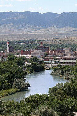
 Overview of downtown, looking south toward Casper Mountain, with North Platte River | |
| Nickname: "The Oil City" | |
 Location within Natrona County, Wyoming | |
| Coordinates: 42°51′0″N 106°19′30″W / 42.85000°N 106.32500°W | |
| Country | |
| State | |
| County | Natrona |
| Government | |
| • Type | Council–manager[1] |
| Area | |
| • City | 26.88 sq mi (69.62 km2) |
| • Land | 26.55 sq mi (68.76 km2) |
| • Water | 0.33 sq mi (0.86 km2) |
| Elevation | 5,150 ft (1,560 m) |
| Population | |
| • City | 59,038 |
| • Rank | 2nd in Wyoming |
| • Density | 2,223.9/sq mi (858.7/km2) |
| • Urban | 67,751 |
| • Metro | 79,955 |
| Time zone | UTC−7 (MST) |
| • Summer (DST) | UTC−6 (MDT) |
| ZIP Codes | 82601–82602, 82604–82605, 82609, 82615, 82630, 82638, 82646 |
| Area code | 307 |
| FIPS code | 56-13150[4] |
| GNIS feature ID | 1586424[5] |
| Website | casperwy.gov |
Casper is an American city in the state of Wyoming. It is in Natrona County. About 60,000 people live in Casper. Casper has an area of about 27 square miles and sits at an elevation of 5,150 feet.
References
[change | change source]- ↑ "City Council and Manager - City of Casper". City of Casper. Retrieved December 18, 2019.
- ↑ "2020 U.S. Gazetteer Files". United States Census Bureau. Retrieved March 22, 2024.
- ↑ "QuickFacts: Casper city, Wyoming". United States Census Bureau. Retrieved March 22, 2024.
- ↑ "U.S. Census website". United States Census Bureau. Retrieved January 31, 2008.
- ↑ "US Board on Geographic Names". United States Geological Survey. October 25, 2007. Retrieved January 31, 2008.
Other websites
[change | change source]![]() Media related to Casper, Wyoming at Wikimedia Commons
Media related to Casper, Wyoming at Wikimedia Commons


