Tamarugal Province
Tamarugal
Provincia de Tamarugal | |
|---|---|
| Coordinates: 20°15′34″S 69°47′10″W / 20.25944°S 69.78611°W | |
| Country | |
| Region | Tarapacá |
| Capital | Pozo Almonte |
| Comunas | List of 5: |
| Government | |
| • Type | Provincial |
| • Governor | Claudio Vila Bustillos |
| Area | |
| • Total | 39,390.5 km2 (15,208.8 sq mi) |
| Population (2002 Census)[2] | |
| • Total | 22,531 |
| • Density | 0.57/km2 (1.5/sq mi) |
| Time zone | UTC-4 (CLT) |
| • Summer (DST) | UTC-3 (CLST) |
| Area code | 56 + 57 |
| Website | Official website |
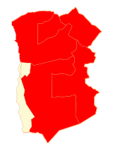
Tamarugal (Spanish: Provincia de Tamarugal) is one of two provinces in the northern Chilean region of Tarapacá (I). The capital is the city of Pozo Almonte.
Tamarugal means "a place where there are many tamarugos"; tamarugo (Prosopis tamarugo) is a tree endemic to the arid lands of northern Chile.
Geography
The Tamarugal province has an area of 39,390.5 km2 (15,208.8 sq mi).[2]
Tamarugal is bordered on the north by the Arica and Parinacota region, on the east by Bolivia, on the south by the Antofagasta region and on the west by the Iquique province and the Pacific Ocean.
Population
As of 2002[update] (last national census), there were 22,531 people living in the province, giving it a population density of 0.6 inhabitants/km².[2]
The largest city of the province is Pozo Almonte, its capital, with a population, in 2002, of 6,384 inhabitants.
Administration
As a province, Tamarugal is a second-level administrative division, consisting of five communes (comunas). The city of Pozo Almonte serves as the provincial capital. The province is administered by a governor.

| Code | Comuna | Capital | Area[2] (km²) |
Population[2] (2002) |
|---|---|---|---|---|
| 01401 | Pozo Almonte | 7 Pozo Almonte | 13,765.8 | 10,830 |
| 01402 | Camiña | 3 Camiña | 2,200.2 | 1,275 |
| 01403 | Colchane | 4 Colchane | 4,015.6 | 1,649 |
| 01404 | Huara | 5 Huara | 10,474.6 | 2,599 |
| 01405 | Pica | 6 Pica | 8,934.3 | 6,178 |
| Total of Tamarugal province | 39,390.5 | 22,531 | ||
References
- ↑ "Gobernaciones". Intendencia - Region of Tarapacá (in Spanish). Retrieved 12 July 2016.
- ↑ 2.0 2.1 2.2 2.3 2.4 2.5 "Región de Tarapacá" (PDF). Instituto Nacional de Estadísticas. Archived from the original (PDF) on 4 May 2012. Retrieved 12 July 2016.
Other websites
- Territorial division of Chile (in Spanish)
- Gobierno Regional de Tarapacá (in Spanish)
- Province of Iquique website (in Spanish)


