Naar inhoud springen

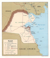
Bestand:Kuwait-Iraq barrier.png

Pagina-inhoud wordt niet ondersteund in andere talen.
Uit Wikipedia, de vrije encyclopedie

Oorspronkelijk bestand (1.060 × 1.218 pixels, bestandsgrootte: 964 kB, MIME-type: image/png)

Transwiki approved by: w:en:User:Dmcdevit

This image was copied from wikipedia:en. The original description was:

Original map license (map from the CIA):

Public domain This image is a work of a Central Intelligence Agency employee, taken or made as part of that person's official duties. As a Work of the United States Government, this image or media is in the public domain in the United States.

čeština  Deutsch  eesti  English  español  français  italiano  português  polski  sicilianu  slovenščina  suomi  Tiếng Việt  български  македонски  русский  українська  বাংলা  മലയാളം  한국어  日本語  中文  中文(简体)  中文(繁體)  العربية  پښتو  +/−

Source: Courtesy of the University of Texas Libraries, The University of Texas at Austin for the map originally found at : http://www.lib.utexas.edu/maps/middle_east_and_asia/kuwait_pol96.jpg

Modified map license (the one that can be seen here)

Public domain Ik, de auteursrechthebbende van dit werk, geef dit werk vrij in het publieke domein. Dit is wereldwijd van toepassing.
In sommige landen is dit wettelijk niet mogelijk; in die gevallen geldt:
Ik sta iedereen toe dit werk voor eender welk doel te gebruiken, zonder enige voorwaarden, tenzij zulke voorwaarden door de wet worden voorgeschreven.

I drew the barrier on the map, based on the fact it extends 6 miles into Iraq and 3 into Kuwait.

Note

Even though this is a .png file the original file is .jpg, so the quality is fairly low.

.xcf version, can be opened in w:en:GIMP

here

Oorspronkelijk uploadlogboek

date/time username resolution size edit summary
16:27, 21 June 2007 w:en:User:Jackaranga 1060×1218 1.38 MB {{BadJPG}} ==Original map license (map from the CIA):== {{PD-USgov}} Source: ''Courtesy of the University of Texas Libraries, The University of Texas at Austin'' for the map originally found at : http://www.lib.utexas.edu/maps/middle_east_and_asia/kuwait

Image description page history

link date/time username edit summary
http://en.wikipedia.org/w/index.php?title=Image:Kuwait-Iraq_barrier.png&redirect=no&oldid=139701165 08:50, 7 September 2007 w:en:User:Dmcdevit
http://en.wikipedia.org/w/index.php?title=Image:Kuwait-Iraq_barrier.png&redirect=no&oldid=139701165 16:52, 21 June 2007 w:en:User:Jackaranga
http://en.wikipedia.org/w/index.php?title=Image:Kuwait-Iraq_barrier.png&redirect=no&oldid=139696697 16:31, 21 June 2007 w:en:User:Jackaranga
http://en.wikipedia.org/w/index.php?title=Image:Kuwait-Iraq_barrier.png&redirect=no&oldid=139695842 16:27, 21 June 2007 w:en:User:Jackaranga ({{BadJPG}} ==Original map license (map from the CIA):== {{PD-USgov}} Source: ''Courtesy of the University of Texas Libraries, The University of Texas at Austin'' for the map originally found at : http://www.lib.utexas.edu/maps/middle_east_and_asia/kuwait)

Bijschriften

Beschrijf in één regel wat dit bestand voorstelt

Items getoond in dit bestand

beeldt af

Bestandsgeschiedenis

Klik op een datum/tijd om het bestand te zien zoals het destijds was.

Datum/tijdMiniatuurAfmetingenGebruikerOpmerking
huidige versie7 apr 2021 23:42Miniatuurafbeelding voor de versie van 7 apr 2021 23:421.060 × 1.218 (964 kB)JohnVanVlietjpg artifact removal
8 sep 2007 05:51Miniatuurafbeelding voor de versie van 8 sep 2007 05:511.060 × 1.218 (1,38 MB)BetacommandBotTranswiki approved by: w:en:User:Dmcdevit This image was copied from wikipedia:en. The original description was: {{BadJPG}} ==Original map license (map from the CIA):== {{PD-USGov-CIA}} Source: ''Courtesy of the University of Texas Libraries, The U

Dit bestand wordt op de volgende 2 pagina's gebruikt:

Globaal bestandsgebruik

De volgende andere wiki's gebruiken dit bestand:

Metadata