File:Mir reentry map.svg
Appearance

Size of this PNG preview of this SVG file: 428 × 377 pixels. Other resolutions: 273 × 240 pixels | 545 × 480 pixels | 872 × 768 pixels | 1,163 × 1,024 pixels | 2,325 × 2,048 pixels.
Original file (SVG file, nominally 428 × 377 pixels, file size: 89 KB)
File history
Click on a date/time to view the file as it appeared at that time.
| Date/Time | Thumbnail | Dimensions | User | Comment | |
|---|---|---|---|---|---|
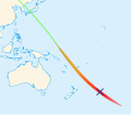
| current | 09:50, 8 September 2009 |  | 428 × 377 (89 KB) | WDGraham | {{Information |Description=Map showing the path taken by w:Mir and w:Progress M1-5 as they reentered the atmosphere over the Pacific Ocean in March 2001.<br/> {{Legend|#4aff1e|Final orbit}} {{Legend|#e89f1e|Entry interface}} {{Legend|#ff1e1e|Deb |
File usage
The following 3 pages use this file:
Global file usage
The following other wikis use this file:
- Usage on fr.wikipedia.org
- Usage on he.wikipedia.org
- Usage on it.wikipedia.org
- Usage on ja.wikipedia.org
- Usage on pl.wikipedia.org
- Usage on ps.wikipedia.org
- Usage on pt.wikipedia.org
- Usage on ru.wikipedia.org
- Usage on sk.wikipedia.org
- Usage on uk.wikipedia.org
- Usage on vi.wikipedia.org
- Usage on www.wikidata.org
