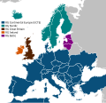
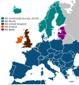
File:ElectricityUCTE.svg
Appearance

Size of this PNG preview of this SVG file: 621 × 600 pixels. Other resolutions: 249 × 240 pixels | 497 × 480 pixels | 795 × 768 pixels | 1,061 × 1,024 pixels | 2,121 × 2,048 pixels | 1,450 × 1,400 pixels.
Original file (SVG file, nominally 1,450 × 1,400 pixels, file size: 353 KB)
File history
Click on a date/time to view the file as it appeared at that time.
| Date/Time | Thumbnail | Dimensions | User | Comment | |
|---|---|---|---|---|---|
| current | 16:07, 10 December 2022 |  | 1,450 × 1,400 (353 KB) | Iktsokh | Size correction |
| 15:24, 30 September 2022 |  | 1,450 × 1,400 (259 KB) | Angelgreat | Changed canvas size and position | |
| 01:56, 30 September 2022 |  | 1,500 × 1,350 (273 KB) | Angelgreat | Resize canvas | |
| 01:46, 30 September 2022 |  | 1,450 × 1,360 (218 KB) | Angelgreat | Change font to be the same as the previous text | |
| 01:42, 30 September 2022 |  | 1,450 × 1,360 (217 KB) | Angelgreat | Replaced the vector text | |
| 21:20, 21 April 2022 |  | 1,450 × 1,360 (237 KB) | M.Bitton | per Graphics_Lab/Map_workshop#ENTSO-E_map | |
| 16:46, 16 March 2022 |  | 1,450 × 1,360 (344 KB) | Kamran.nef | Changed dimensions to fully fit Ukraine. | |
| 15:41, 16 March 2022 |  | 1,280 × 1,360 (489 KB) | Liebeskind | "Continental Europe successful synchronisation with Ukraine and Moldova power systems" https://www.entsoe.eu/news/2022/03/16/continental-europe-successful-synchronisation-with-ukraine-and-moldova-power-systems/ | |
| 11:28, 21 June 2018 |  | 1,280 × 1,360 (488 KB) | Wdwd | Update: Turkey, Morroco, Algeria, Tunisia are part of the european electricity power grid, former UCTE network. | |
| 10:42, 8 March 2018 |  | 1,280 × 1,360 (334 KB) | NordNordWest | cleaned |
File usage
The following 10 pages use this file:
- Electric power transmission
- Electrical grid
- European Market Coupling Company
- European Network of Transmission System Operators for Electricity
- European integration
- Synchronous grid of Continental Europe
- Synchronous grid of Northern Europe
- Wide area synchronous grid
- Wikipedia:Graphics Lab/Image workshop/Archive/Sep 2009
- Wikipedia:Graphics Lab/Map workshop/Archive/Apr 2022
Global file usage
The following other wikis use this file:
- Usage on ast.wikipedia.org
- Usage on bg.wikipedia.org
- Usage on ca.wikipedia.org
- Usage on cs.wikipedia.org
- Usage on de.wikipedia.org
- Usage on es.wikipedia.org
- Usage on fi.wikipedia.org
- Usage on fr.wikipedia.org
- Usage on fr.wikinews.org
- Usage on id.wikipedia.org
- Usage on lb.wikipedia.org
- Usage on nl.wikipedia.org
- Usage on nn.wikipedia.org
- Usage on no.wikipedia.org
- Usage on ru.wikipedia.org
- Usage on sv.wikipedia.org
- Usage on th.wikipedia.org
- Usage on tr.wikipedia.org
- Usage on uk.wikipedia.org
- Usage on zh.wikipedia.org
