
Waitaki District

The Waitaki district, in the Canterbury and Otago regions of New Zealand, straddles the traditional border between the two regions, the Waitaki River. It has a land area of 7,151.94 km² (2,761.38 sq mi), divided 59.28% to Canterbury Region and 40.72% to Otago Region. It is the only district on the South Island that is divided between two regions. The district, which is agricultural by nature, comprises the wide alluvial fan of the river, and runs inland along the banks of the river, this forming a roughly triangular region. Oamaru (in Otago) is the largest town in the district. More information about the population and the district is presented on the Oamaru page.
The Waitaki District is made up of the former Waitaki County and Oamaru Borough, which were merged in 1989. It is governed by the Waitaki District Council.
External links
- Waitaki District Council
- Information about Waitaki District
- Waitaki Development Board
- Tourist information
-
 Crest of the Waitaki District Council
 -
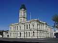 Council offices as seen from Thames Street


This Otago geography article is a stub. You can help Wikipedia by expanding it. |
This Canterbury Region-related geography article is a stub. You can help Wikipedia by expanding it. |