
File:Kosi catchment.jpg

Size of this preview: 765 × 600 pixels. Other resolutions: 306 × 240 pixels | 612 × 480 pixels | 979 × 768 pixels | 1,280 × 1,004 pixels | 1,418 × 1,112 pixels.
Original file (1,418 × 1,112 pixels, file size: 473 KB, MIME type: image/jpeg)
| This is a file from the Wikimedia Commons. Information from its description page there is shown below. Commons is a freely licensed media file repository. You can help. |
| Description |
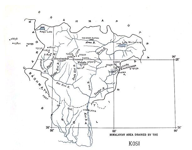
Map of the catchment zones for the Kosi river |
|||||||||
| Date | ||||||||||
| Source | A sketch of the geography and geology of the Himalaya Mountains and Tibet | |||||||||
| Creator |
S.G. Burrard |
|||||||||
| Permission (Reusing this file) |
|
|||||||||
| Geotemporal data | ||||||||||
| Bounding box |
|
|||||||||
| Georeferencing | ||||||||||
File history
Click on a date/time to view the file as it appeared at that time.
| Date/Time | Thumbnail | Dimensions | User | Comment | |
|---|---|---|---|---|---|
| current | 08:23, 7 September 2017 | | 1,418 × 1,112 (473 KB) | Shyamal | {{Information |Description=Map of the catchment zones for the Kosi river |Source=[https://archive.org/stream/sketchofgeograph00burr#page/n314/mode/1up A sketch of the geography and geology of the Himalaya Mountains and Tibet ] |Date=1907 |Author=S.G. B... |
File usage
The following page uses this file:
Global file usage
The following other wikis use this file:
- Usage on sl.wikipedia.org