Ossoliński Alley, Bydgoszcz
| Bydgoszcz | |
|---|---|
 View of the street | |
 Location of Ossoliński Alley | |
| Native name | Aleja Ossolińskich w Bydgoszczy (Polish) |
| Former name(s) | Hohenzollernstrasse, Johann Herder Allee |
| Part of | Bydgoszcz Old town district |
| Namesake | House of Ossoliński |
| Owner | City of Bydgoszcz |
| Length | 500 m (1,600 ft) |
| Location | Bydgoszcz, |
Ossoliński Alley is a large dual carriageway road located in downtown Bydgoszcz.
Location
The avenue is located in the eastern part of the downtown Bydgoszcz and links J. Weyssenhoff Square with Ossoliński roundabout.
Naming
Through history, this street had the following names:[1]
- From 1906 to 1920, Hohenzollernstrasse, from the House of Hohenzollern;
- From 1920 to 1939, Ossoliński Alley;
- From 1939 to 1945, Johann Herder Allee;
- Since 1945, Ossoliński Alley
The namesake of the street comes from is among the House of Ossoliński, associated with Bydgoszcz in the 17th century with in particular Jerzy Ossoliński (1633–1645, 1648–1650) and his son Francis (1645–1648), Starosts of Bydgoszcz and Crown Chancellor.
History
Ossoliński Alley has been laid out in 1903, in the same conditions of urban development as Adam Mickiewicz Alley in the eastern area of Gdańska Street called "Hempelscher Felde":[2] this plot was bought in the 1890s by the municipality to develop a garden city, the Sielanka estate, based on the works of Hermann Stübben.[3]
This axis was a dual carriageway avenue lined up with trees, called Hohenzolernstrasse in its south part, Bülowstrasse in it north part (in 1920 it became part of Adam Mickiewicz alley). The construction of the avenue has been completed in 1903; this was then the widest street in the city: 40 m wide, it had two carriageways, and in a pedestrian walkway in the middle with lawn and trees (red oaks with festoons of Virginia creepers.[4] Street inception was in direct relationship with the erection in 1902 of buildings for the Kaiser Wilhelm's first university and scientific institution in Bydgoszcz (German: Kaiser "Wilhelm's Institut für Landwirtschaft zu Bromberg").[2] The institute architectural ensemble has been erected on the eastern side of the street between 1903 and 1906. By contrast, the area on the western side of the alley has been planned and designed in 1912 by German architect Josef Stübben. However, most of the villas in this district ("Sielanka" or Idyll) have been essentially erected during interwar period.[5]
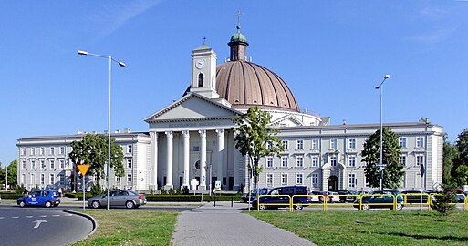
In 1924, the south-western tip of Ossoliński Alley has been identified to accommodate the construction of St. Vincent de Paul's Basilica, the largest religious edifice in Bydgoszcz, and one of the largest in Poland. The whole complex has only been completed in 2003.[6]


In the 1950s, an urbanization project designed and created in Bydgoszcz two "clone" avenues of Ossoliński alley with two lanes, middle tree planted sidewalk: 11 November street (Leśne district) and Stanisław Noakowski street (Kapuściska district).
Green
The alley has two rows of red oaks planted at the beginning of the 20th centurytwentieth century. Four of them are listed as Polish monuments of nature:[7]
- Three Magnolias at 12;
- One horse-chestnut at 3.
Karol Szymanowski alley, crossing the southern part of Ossoliński avenue is unique by the presence of a monumental perspective of 46 specimens of Swedish whitebeams, all listed as Polish monuments of nature.[7]
Main places and buildings
St. Vincent de Paul's Basilica, at 2
Registered on Kuyavian-Pomeranian Voivodeship heritage list, Nr.601231, Reg. A/846/1-2, 30 May 1996.[8]
1925-1939, by Adam Ballenstedt
The basilica, completed in 1945, has been designed by Polish architect Adam Ballenstedt and comprises the church, a monastery and a park. Minor Basilica dedication has been carried out during a ceremony chaired by Pope John Paul II, on 3 June 1997[9]
-
General view
-
Doors of Blessings
-
Nave view
-
Inside dome
Buildings of the Institute of Agriculture
Registered on Kuyavian-Pomeranian Voivodeship heritage list, Nr.601253, Reg. A/676/1-8, 20 May 1992[8]
1903-1906, by H. Delius
The architectural ensemble of the Institutes of Agriculture in Bydgoszcz occupies an area of 7.5 hectares, between J. Weyssenhoff Square, Ossolińsky Alley, Powstańców Wielkopolskich Alley and Karol Szymanowski Street. The western area is laid out with buildings, the eastern one is a 5 ha zone of field vegetation, with livestock, greenhouses and a barn.[10]
-
Main facade of Nr.4/6
-
Detail of Nr.4
-
View of Nr.6 on foreground
-
Detail of half-timbered elements
-
Facade of Nr.8/10
-
Side view of Nr.8/10
12 Ossoliński Alley
Registered on Kuyavian-Pomeranian Voivodeship heritage list, Nr.601256, Reg.A/676/1-8, 20 May 1992.[8]
This building originally housed the Institute of Agrochemistry and Bacteriology.
-
Main view from the street
-
Side View
-
Detail of the roof
Villa at 5
1935 by Jan Kossowski[11]
The house has been designed for Ludwig Stojowski, a banker.[12]
-
View from the street
Villa at 7
Registered on Kuyavian-Pomeranian Voivodeship heritage list, Nr.601388, Reg. A/1050, 31 December 1997.[8]
1927-1929 by Bronisław Jankowski[11]
Polish National Style
This large house, (620 m2), was supposed to be a residential building with a lawyer office for a famous family of Polish interwar, the Felcynów[13] In the 1930s, the villa housed the "Headquarters District Command of Border Guard", then, during the nazi occupation, the Westpreussen seat of Selbstschutz of western Prussia. During those dark times, it also housed the Abwehr: the decoration included a series of rooms dedicated for senior military officers (spa and leisure facilities).[13]
After World War II, it was used by NKVD, and between 1947 and 2004, a delegation of Polish Supreme Audit Office used the building. On the facade a plaque by Alexander Dętkoś, unveiled on 17 September, commemorates Polish Border Guard personnel murdered by NKVD soldiers during the Katyn massacre.[14]
-
View of the front facade
-
Side view
-
Commemorating plaque
Villa at 9
1927-1931 by Edward Stecewicz[11]
-
View from the street
-
Side view
Villa at 11
1932-1933 by Henryk Misterek[15]
-
Main facade from the street
-
Backside view
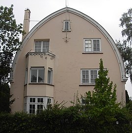
Villa at 16 Kopernika Street, corner with Ossoliński Alley
Registered on Kuyavian-Pomeranian Voivodeship heritage list, Nr.601364, Reg. A/61/1-2, January 20, 2002[8]
1933, by Antoni Weynerowski[16]
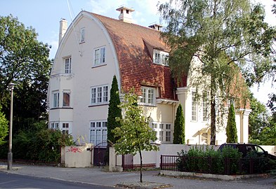
The house has been commissioned by Antoni Weynerowski, owner of a successful shoe factory LEO', then KOBRA in the early 20th century, as a wedding gift for his son Witold and his wife Julia. She was from Dutch ascendance, hence the choice of the design, with a de l'Orme roof.[17] After World War II, the villa moved into the hands of the city authorities and became a kindergarten for police members.[17]
-
View from street intersection
-
General view with the gable of the garage building on the right
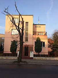
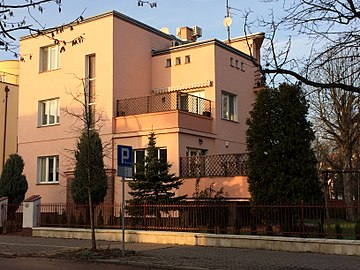
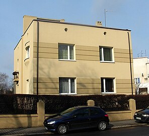
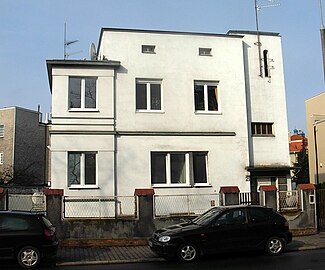
Villa at 9 Kopernika Street, corner with Ossoliński Alley
1932-1933, by Bolesław Polakiewicz[18]
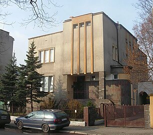
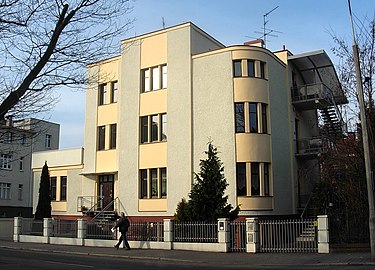
Early modernism, Functionalism
In 1932-1933, Bolesław Polakiewicz realized 9 projects in the area, all characterized by functionalist style: cubic or rectangular forms with enhanced architectural effects.[19]
-
View from Kopernika Street
-
View from Ossoliński Alley
-
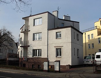
General view with Kopernika Street Nr.9 (center), 7a (right) and 16 (left)
Villa at 17
1932-1933 by Bolesław Polakiewicz[11]
-
Main facade from the street
Villa at 19
1932-1933 by Bolesław Polakiewicz[11]
-
Main facade from the street
Villa at 21
1932-1933 by Bolesław Polakiewicz[11]
-
Main facade from the street
Villa at 23, corner with 6 Asnyka street
1933-1934,[20] by Jan Kossowski[11]
One of the houses part of the Sielanka estate project in the 1930s.
-
View from Ossoliński Alley
Villa at 25
1927-1929 by Bronisław Jankowski[11]
Polish National Style
Houses a local branch of a bank.
-
Main facade by night
-
Side view
-
Side view
See also
- Kopernika Street in Bydgoszcz
- St. Vincent de Paul Basilica Minor in Bydgoszcz
- Pomeranian Philharmonic
- Gdańska Street, Bydgoszcz
- Adam Mickiewicz Alley in Bydgoszcz
- Józef Weyssenhoff Square in Bydgoszcz
- Bydgoszcz
References
- ^ Czachorowski, Antoni (1997). Atlas historyczny miast polskich. Tom II Kujawy. Zeszyt I Bydgoszcz. Toruń: Uniwersytet Mikołaja Kopernik.
- ^ a b Jastrzębska-Puzowska, Iwona (2005). Od miasteczka do metropolii. Rozwój architektoniczny i urbanistyczny Bydgoszczy w latach 1850-1920. Toruń: Wydawnictwo MADO. ISBN 83-89886-38-3.
- ^ Bydgoszcz Guide. Bydgoszcz: City of Bydgoszcz. July 2014. p. 22. ISBN 83-917786-7-3.
- ^ Kuczma, Rajmund (1995). Zieleń w dawnej Bydgoszczy. Bydgoszcz: Instytut Wydawniczy „Świadectwo”.
- ^ Okoń Emanuel, Tandecki Janusz (1997). Bydgoszcz – historia i rozwój przestrzenny. Atlas historyczny miast polskich. Tom II Kujawy. Zeszyt I Bydgoszcz. Toruń: Uniwersytet Mikołaja Kopernika.
- ^ Umiński, Janusz. Bydgoszcz. Przewodnik. Bydgoszcz: Regionalny Oddział PTTK „Szlak Brdy”. p. 1996.
- ^ a b Kaja, Renata (1995). Bydgoskie pomniki przyrody. Bydgoszcz: Instytut Wydawniczy „Świadectwo”. ISBN 83-85860-32-0.
- ^ a b c d e zabytek|kujawsko-pomorskie|issued=1.03.2014
- ^ Wojtonis, Tadeusz (2014). "Historia Parafii". bydgoskabazylika.pl. bydgoskabazylika. Retrieved 12 February 2017.
- ^ Grzybowska Maria, Werterowska Zofia (1999). Przyczynki do historii architektury zespołu naukowych Instytutów Rolniczych w Bydgoszczy. Bydgoszcz: Pracownia Dokumentacji i Popularyzacji Zabytków Wojewódzkiego Ośrodka Kultury w Bydgoszczy. p. 60.
- ^ a b c d e f g h Derkowska-Kostkowska, Bogna (1999). o zalozeniu Sielanki-bydgoskiego miasta ogrodu. Materialy do Dziejów Kultury i Sztuki Bydgoszczy i Regionu. zeszyt 4 (in Polish). Bydgoszcz: Pracownia Dokumentacji i Popularyzacji Zabytków Wojewódzkiego Osrodka Kultury w Bydgoszczy. pp. 72–85.
- ^ Spacer Modernizm po Bydgoszczy. Bydgoskie Centrum Informacji. 2018. pp. 1–2.
- ^ a b Kaczmarczyk, Henryk (1996). Budynek przy alei Ossolińskich. Bydgoszcz: Kalendarz Bydgoski. p. 111.
- ^ Umiński, Janusz (2004). Przewodnik, Wydawnictwo Uczelniane Wyższej Pomorskiej Szkoły Turystyki i Hotelarstwa w Bydgoszczy. Bydgoszcz. ISBN 83-914008-7-5.
{{cite book}}: CS1 maint: location missing publisher (link) - ^ Wysocka Agnieszka, Daria Bręczewska-Kulesza (2003). Wille na Sielance. Kronika Bydgoska Zeszyt 25 (in Polish). Bydgoszcz: Towarzystwo Miłosnikow Miasta Bydgoszczy - Bydgoskie Towarzystwo Naukowe. p. 57.
- ^ Sowińska, Hanka (9 November 2012). "Bydgoskie rody: Weynerowscy i "Leo"". pomorska.pl. Polska Press Sp. z o. o. Retrieved 2 March 2021.
- ^ a b Bydgoszcz Guide. Bydgoszcz: City of Bydgoszcz. July 2014. p. 108. ISBN 83-917786-7-3.
- ^ Derkowska - Kostkowska, Bogna (1999). O zalozeniu Sielanki - bydgoskiego miasta ogrodu. Materiały do dziejow kultury i sztuki bydgoszczy T4. Bydgoszcz: Pracownia Dokumentacji i Popularyzacji zabytków Wojewódzkiego osrodja kultury w Bydgoszczy. p. 72.
- ^ Derkowska - Kostkowska, Bogna (1999). O zalozeniu Sielanki - bydgoskiego miasta ogrodu. Materiały do dziejow kultury i sztuki bydgoszczy T4. Bydgoszcz: Pracownia Dokumentacji i Popularyzacji zabytków Wojewódzkiego osrodja kultury w Bydgoszczy. p. 82.
- ^ Prezidenta Miasta Bydgoszczy (7 August 2015). Zarządzenie Nr439/2015. Bromberg: Prezidenta Miasta Bydgoszczy. p. 5.
External links
- (in Polish) Official page of Basilica's parish
Bibliography
- (in Polish) Kaczmarczyk, Henryk (1996). Budynek przy alei Ossolińskich. Kalendarz Bydgoski. Bydgoszcz: Towarzystwo Miłośników Miasta Bydgoszczy. pp. 111–113.
- (in Polish) Czachorowski, Antoni (1997). Atlas historyczny miast polskich. Tom II Kujawy. Zeszyt I Bydgoszcz. Toruń: Uniwersytet Mikołaja Kopernika.
- (in Polish) Jastrzębska-Puzowska, Iwona (2005). Od miasteczka do metropolii. Rozwój architektoniczny i urbanistyczny Bydgoszczy w latach 1850-1920. Toruń: Wydawnictwo MADO. ISBN 9788389886385.
- (in Polish) Umiński, Janusz (1996). Bydgoszcz – przewodnik. Bydgoszcz: Regionalny Oddział PTTK „Szlak Brdy”.
- (in Polish) Sroka CM, Zbigniew. Bazylika św. Wincentego à Paulo w Bydgoszczy – przewodnik. Bydgoszcz.
- (in Polish) A. Konsek CM, ks. A. Strycharz CM (1999). Bydgoska Bazylika Mniejsza św. Wincentego à Paulo 1924 – 1999. Bydgoszcz.
{{cite book}}: CS1 maint: location missing publisher (link)

