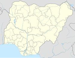
Langtang South
Langtang South | |
|---|---|
| Coordinates: 8°38′N 9°48′E / 8.633°N 9.800°E | |
| Country | |
| State | Plateau State |
| Headquarters | Mabudi |
| Area | |
| • Total | 838 km2 (324 sq mi) |
| Population (2006 census) | |
| • Total | 106,305 |
| Time zone | UTC+1 (WAT) |
| 3-digit postal code prefix | 941 |
| ISO 3166 code | NG.PL.LS |
 | |
Langtang South is a Local Government Area in Plateau State, Nigeria. Its headquarters are in the town of Mabudi.
It has an area of 838 km2 and a population of 106,305 at the 2006 census.
The postal code of the area is 941.[1]
As of July 2014[update] Hon. Beni Lar represents the Langtang North and Langtang South constituency in the [[House of Representatives (Nigeria)|House of Representatives] Hon Nanfa Nbin was sworn in as the Executive Chairman of Langtang South on 10th October 2024]. The Local Government has a Chief Magistrate Court located in Mabudi and 3 Area Courts located in Sabon Gida, Dadin Kowa and Magama.[2]
Climate/Geography
Langtang, which is 0 feet (0 meters) above sea level, has a tropical wet and dry climate, often known as a savanna climate (Classification: Aw). The district experiences an annual temperature of 26.91 °C (80.44 °F), which is -2.55% colder than the average for Nigeria. Approximately 147.33 millimeters (5.8 inches) of precipitation and 172.0 wet days (47.12% of the total) are experienced annually in Langtang.[3]
Langtang experiences a whole year of intense heat waves, partially cloudy dry seasons, and terrible wet season. It rarely drops below 59 °F or rises over 104 °F throughout the year, with average temperatures fluctuating between 64 °F and 100 °F. The average daily maximum temperature during the 2.5-month hot season, which runs from January 31 to April 15, is above 96 °F. At 99 °F on average for highs and 74 °F on average for lows, March is the hottest month of the year in Langtang.[4]
With an average daily maximum temperature below 86 °F, the chilly season spans 3.8 months, from June 24 to October 17. With an average low temperature of 71 °F and high temperature of 83 °F, August is the coldest month of the year in Langtang south.[5]
An average of 27 degrees Celsius is experienced in Langtang South LGA, which spans an area of 838 square kilometers. Two separate seasons—the dry and the rainy—are experienced in the area. Langtang North LGA receives an estimated 1900 mm of precipitation annually in total.[6][5]
See also
- Langtang, town
- Langtang North Local Government Area
Langtang South,Nigeria.
  Langtang, Nigeria is
 classified into two main category or segments, and this categories are:
 (1)Langtang North and
 (2)Langtang South.
The entered Langtang north and Langtang South are well considered to be as one Tribe, known as The Tarok Land.
    The community name
   listed below are some of the Langtang South community that are around the Mabudi Community (The center of Langtang South Lga.
  (1)Telfirm Community,
  (2)Kamkun Community,
  (3)Talgwang "
  (4)Mangwang "
  (5)Sabongida "
  (6)Gamankai  "
  (7)Nagani    "
  (8)Ubang    "
  (9)Gina-Rumbu "
  (10)Dadinkowa "
  (11)Zambang "
and(12)Lashel "etc.
- ^ "Post Offices- with map of LGA". NIPOST. Archived from the original on 2012-11-26. Retrieved 2009-10-20.
- ^ Hamza Idris; Yahaya Ibrahim (2014-07-15). "Nigeria: 38 Killed As Boko Haram Attacks Borno Village". Daily Trust - AllAfrica. Retrieved 2014-07-18.
- ^ "Langtang Climate, Weather By Month, Average Temperature (Nigeria) - Weather Spark". weatherspark.com. Retrieved 2024-08-22.
- ^ "Langtang, Plateau, NG Climate Zone, Monthly Averages, Historical Weather Data". weatherandclimate.com. Retrieved 2024-08-22.
- ^ a b "Langtang South Local Government Area". www.manpower.com.ng. Retrieved 2024-08-22.
- ^ "Langtang South, Nigeria 10-Day Weather Forecast | Weather Underground". www.wunderground.com. Retrieved 2024-08-22.


