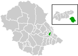
Gaimberg
Appearance
Gaimberg | |
|---|---|
 Location within Lienz district | |
| Coordinates: 46°50′43″N 12°47′08″E / 46.84528°N 12.78556°E | |
| Country | Austria |
| State | Tyrol |
| District | Lienz |
| Government | |
| • Mayor | Bartholomäus Klaunzer |
| Area | |
• Total | 7.28 km2 (2.81 sq mi) |
| Elevation | 758 m (2,487 ft) |
| Population (2018-01-01)[2] | |
• Total | 822 |
| • Density | 110/km2 (290/sq mi) |
| Time zone | UTC+1 (CET) |
| • Summer (DST) | UTC+2 (CEST) |
| Postal code | 9900 |
| Area code | 04852 |
| Vehicle registration | LZ |
| Website | www.gaimberg.at |
Gaimberg is a municipality in the district of Lienz in the Austrian state of Tyrol. It is situated north of the town of Lienz. The neighbouring municipalities are Lienz, Nußdorf-Debant, and Thurn. The municipality consists of the following neighbourhoods: Grafendorf, Obergaimberg, Untergaimberg, Kranzhofsiedlung and Wartschensiedlung.
Population
[edit]| Year | Pop. | ±% |
|---|---|---|
| 1869 | 393 | — |
| 1880 | 436 | +10.9% |
| 1890 | 335 | −23.2% |
| 1900 | 326 | −2.7% |
| 1910 | 343 | +5.2% |
| 1923 | 328 | −4.4% |
| 1934 | 381 | +16.2% |
| 1939 | 414 | +8.7% |
| 1951 | 433 | +4.6% |
| 1961 | 492 | +13.6% |
| 1971 | 617 | +25.4% |
| 1981 | 709 | +14.9% |
| 1991 | 707 | −0.3% |
| 2001 | 767 | +8.5% |
| 2011 | 835 | +8.9% |
References
[edit]- ^ "Dauersiedlungsraum der Gemeinden Politischen Bezirke und Bundesländer - Gebietsstand 1.1.2018". Statistics Austria. Retrieved 10 March 2019.
- ^ "Einwohnerzahl 1.1.2018 nach Gemeinden mit Status, Gebietsstand 1.1.2018". Statistics Austria. Retrieved 9 March 2019.
Wikimedia Commons has media related to Gaimberg.


