Size of this preview: 611 × 599 pixels. Other resolutions: 245 × 240 pixels | 489 × 480 pixels | 783 × 768 pixels | 1,044 × 1,024 pixels | 2,088 × 2,048 pixels | 4,750 × 4,660 pixels.
Original file (4,750 × 4,660 pixels, file size: 14.75 MB, MIME type: image/jpeg)
| This is a featured picture, which means that members of the community have identified it as one of the finest images on the English Wikipedia, adding significantly to its accompanying article. If you have a different image of similar quality, be sure to upload it using the proper free license tag, add it to a relevant article, and nominate it. |
| This image was selected as picture of the day on the English Wikipedia for July 21, 2010. |
File history
Click on a date/time to view the file as it appeared at that time.
| Date/Time | Thumbnail | Dimensions | User | Comment | |
|---|---|---|---|---|---|
| current | 08:14, 31 January 2009 |  | 4,750 × 4,660 (14.75 MB) | Durova | minor tweaks |
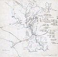
| 06:22, 31 January 2009 |  | 4,750 × 4,660 (14.75 MB) | Durova | {{Information |Description=Confederate map from the American Civil War of First Manassas (First Battle of Bull Run). Includes some troop positions, and lists of Confederate regiments engaged in the battle of Manassas, with the names of their commanders. |
File usage
The following 22 pages use this file:
- Hachure map
- Talk:First Battle of Bull Run/Archive 1
- User:Durova/2009 MILHIST project work
- User:Durova/Featured picture gallery/2009
- User talk:Durova/Archive 65
- User talk:Roger Davies/Archive 2009
- Wikipedia:Featured picture candidates/February-2009
- Wikipedia:Featured picture candidates/First Battle of Manassas map
- Wikipedia:Featured pictures/History/American Civil War
- Wikipedia:Featured pictures thumbs/15
- Wikipedia:Picture of the day/July 2010
- Wikipedia:WikiProject Military history/Showcase
- Wikipedia:WikiProject Military history/Showcase/FP
- Wikipedia:WikiProject United States/Featured pictures
- Wikipedia:WikiProject United States/Quality content
- Wikipedia:WikiProject United States/Recognized content
- Wikipedia:Wikipedia Signpost/2009-02-08/Features and admins
- Wikipedia:Wikipedia Signpost/2009-02-08/SPV
- Wikipedia:Wikipedia Signpost/Single/2009-02-08
- Template:POTD/2010-07-21
- Portal:American Civil War
- Portal:American Civil War/Featured picture
Global file usage
The following other wikis use this file:
- Usage on ar.wikipedia.org
- Usage on es.wikipedia.org
- Usage on fr.wikipedia.org
- Usage on kn.wikipedia.org
- Usage on ms.wikipedia.org
- Usage on www.wikidata.org
